Pakistan and China share a 523-kilometre border running through some of the most remote and high-altitude terrain anywhere in the world. The border traces the Karakoram range from the Wakhan Corridor in the west to the disputed Siachen region in the east, passing through terrain where many points remain unmapped and inaccessible on foot. The Khunjerab Pass is the single point where a paved road crosses this border, connecting Pakistan’s Gilgit-Baltistan with China’s Xinjiang Uyghur Autonomous Region via the Karakoram Highway.
For travellers, the journey from Pakistan to the Khunjerab Pass begins in Islamabad and follows the Karakoram Highway through some of the most dramatic mountain scenery in the world, passing through Hunza Valley, along the shores of Attabad Lake, and through the upper Hunza gorge before arriving at the border gate. Crossroads Adventure’s Hunza and Baltistan premium expedition includes the Khunjerab Pass as its northern terminus, the point where Pakistan meets China at the top of the world.
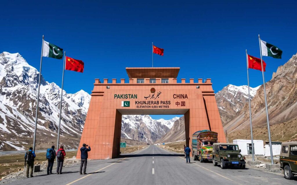
Khunjerab Pass: The World’s Highest Paved Border Crossing
The word Khunjerab comes from the Wakhi language, spoken by the communities of Upper Hunza: khun means blood and jerab means river or waterfall, a reference to the red-coloured minerals that tint some of the mountain streams in the area. The pass sits between Pakistan’s Khunjerab National Park on the south side and China’s Tashkurgan Tajik Autonomous County in Xinjiang on the north side. The landscape at the pass itself is high, bare, and swept by fierce winds, with Karakoram peaks rising in all directions and the flat plateau-like terrain of the pass forming a stark contrast to the dramatic gorges below.
The decision to route the Karakoram Highway through Khunjerab rather than the lower Mintaka Pass to the west was made in 1966 at China’s recommendation. The original choice, Mintaka, was considered too vulnerable to air strikes. The steeper, higher Khunjerab route was chosen instead, and the road was built jointly by Pakistan and China between 1962 and 1979, opened to commercial traffic in 1982, and to the general public in 1986. During construction, the project claimed the lives of approximately 810 Pakistani and 200 Chinese workers, mostly from landslides and falls. Over 140 Chinese workers who died are buried in a dedicated cemetery in Gilgit.
The Karakoram Highway: The Eighth Wonder of the World
The Karakoram Highway (KKH), officially Pakistan’s National Highway 35, runs 1,300 kilometres from Hasan Abdal in Punjab to the Khunjerab Pass in Gilgit-Baltistan, where it crosses into China and continues as China National Highway 314 all the way to Kashgar in Xinjiang. It is one of the highest paved roads in the world and widely described as one of the most spectacular road journeys on Earth. Due to the conditions under which it was built, the altitude it reaches, and the engineering challenges it overcame, it is sometimes called the Eighth Wonder of the World.
The KKH follows one of the ancient branches of the Silk Road, the network of trade routes that connected China to Central Asia, South Asia, and the Mediterranean for over 1,500 years. Before the road existed, traders and pilgrims crossed these mountains on foot or on horseback through the same high passes, carrying silk, spices, jade, and ideas between civilisations. The modern highway has replaced but did not invent this crossing. It simply paved it.
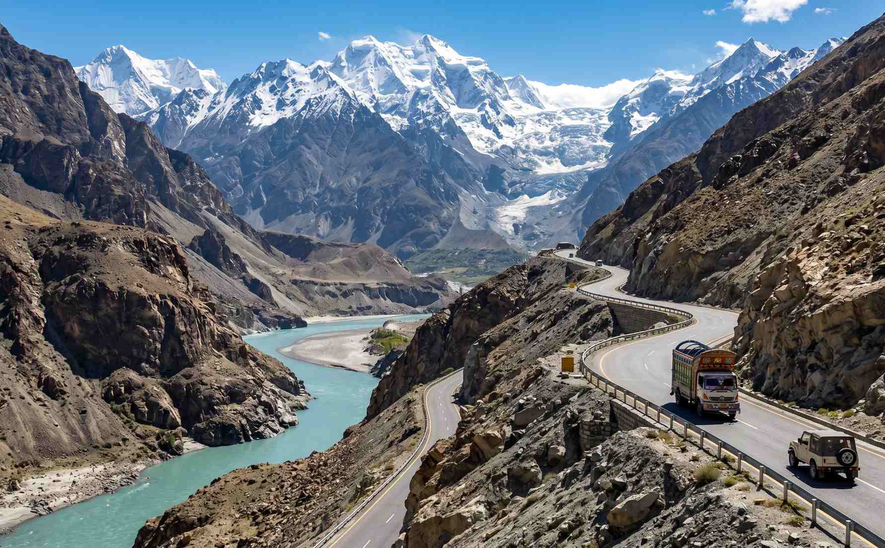
The Karakoram Highway through the Hunza gorge, where the road is carved into cliffs rising over 5,000 metres above the river. Often described as the most dramatic road journey on Earth
The KKH from Islamabad to Khunjerab: Key Milestones
Islamabad / Hasan Abdal
The official start of the N-35 national highway. Most travellers begin from Islamabad and travel via Abbottabad before joining the KKH at Havelian. The first section to Mansehra and Besham passes through green KPK hill country before the mountains become serious.
Besham and the Indus Gorge
The highway joins the Indus River at Thakot and follows it northward for hundreds of kilometres. The Indus gorge between Besham and Chilas is one of the most impressive river canyon sections anywhere in Asia, with the road clinging to cliff faces above the roaring glacial river far below.
Chilas and the Confluence Point
Near Chilas, the KKH passes the ancient rock carvings of Chilas, thousands of inscriptions and images carved by Silk Road travellers over 2,000 years. Nearby is the Jaglot confluence, where the Gilgit River joins the Indus and where the three mountain ranges, the Karakoram, Himalayas, and Hindu Kush, visibly meet in a single view. Nanga Parbat (8,126m) is visible from the highway in this area.
Gilgit City
The capital of Gilgit-Baltistan and the main hub of northern Pakistan. Gilgit has an airport with flights to and from Islamabad, making it an alternative entry point to the upper KKH for travellers unwilling or unable to make the full road journey from Islamabad. The city has been a crossroads of cultures for centuries.
Hunza Valley and Karimabad
The KKH passes through the Hunza Valley, Pakistan’s most celebrated mountain destination. Attabad Lake, Karimabad, Baltit Fort, Altit Fort, and the extraordinary Passu Cones are all accessible from or visible along the highway in this stretch. This is the most scenic section of the entire road and the heart of Crossroads Adventure’s core territory. The Hunza and Baltistan premium expedition is based along this corridor.
Sost: Pakistan’s Last Town Before China
Sost is the Pakistani immigration and customs post, located 85 kilometres south of the Khunjerab Pass gate. All travellers crossing into China clear Pakistani customs here. Sost has basic guesthouses, restaurants, and the Sost Dry Port, which handles the bulk of overland Pakistan-China trade. It is the last settlement of any size before the high pass.
Khunjerab National Park and Dih Checkpoint
Before reaching the pass, travellers enter Khunjerab National Park, which covers over 2,270 square kilometres of high-altitude terrain. Entry fees apply. The Dih checkpoint is the last Pakistani control point before the actual pass. The landscape here opens into a wide, windswept plateau with the peaks of the Karakoram visible in all directions.
Khunjerab Pass: The Border Gate
The border gate marks the precise crossing point between Pakistan and China. A monument and the distinctive gate structure mark the spot. On a clear day, the views in all directions across the high Karakoram plateau are extraordinary. Beyond the gate on the Chinese side, the road descends toward Tashkurgan and Kashgar in Xinjiang. Chinese immigration is handled at Tashkurgan, approximately 100 kilometres beyond the gate.
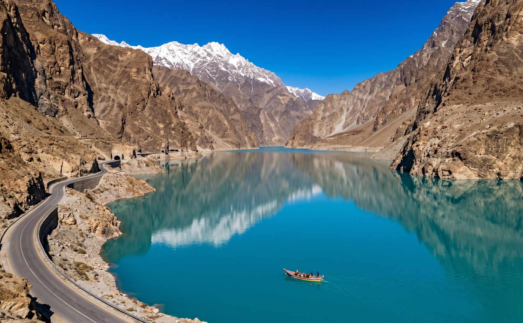
Attabad Lake on the Karakoram Highway, formed in 2010 and now one of the most iconic sights on the drive from Hunza to the Khunjerab Pass
Khunjerab National Park: Wildlife at the Border
The Khunjerab National Park, established in 1975, protects the high-altitude terrain on both sides of the Karakoram Highway in the Hunza and Nagar districts. It is the third-largest national park in Pakistan, covering 2,270 square kilometres of terrain between 2,600 and 6,000 metres above sea level. The park was established primarily to protect the snow leopard, and Khunjerab is one of Pakistan’s most reliable locations for snow leopard presence, though sightings are rare given the cat’s exceptional elusiveness.
The park also hosts significant populations of Marco Polo sheep, Siberian ibex, Himalayan brown bear, marmots, red foxes, and the Eurasian lynx. The Marco Polo sheep (Ovis ammon polii), named after the traveller who first described them in 1271, is the defining large mammal of the Pamir-Karakoram borderlands. Their enormous spiralling horns make them among the most visually striking wild sheep in the world. Yaks, domesticated by the Wakhi communities of Gojal for centuries, graze the high pastures of the park and are a common sight along the upper KKH between Passu and Khunjerab.
The China-Pakistan Economic Corridor: A New Silk Road
The Khunjerab Pass and the Karakoram Highway have taken on new strategic significance as the northern anchor of the China-Pakistan Economic Corridor (CPEC), the flagship infrastructure programme of China’s Belt and Road Initiative. Originally valued at USD 46 billion and grown to over USD 65 billion by 2022, CPEC is one of the largest infrastructure investment programmes ever undertaken in South Asia, encompassing road upgrades, energy projects, special economic zones, and port development from the Pakistani coast at Gwadar to the Chinese border at Khunjerab.
In December 2024, the Khunjerab Pass transitioned to year-round operations for the first time in its history, having previously been closed from November to March due to severe winter conditions. As of the year-round opening, goods can now be transported from Karachi to Kashgar in just eight days, making overland trade between Pakistan and China competitive with sea freight for many product categories. The pass now handles thousands of vehicles and tens of thousands of tonnes of goods annually, carrying Pakistani seafood, fruits, and textiles northward and Chinese machinery, electronics, and manufactured goods southward along the same highway that ancient Silk Road caravans once travelled on foot.
A proposed Khunjerab Railway line that would run parallel to the KKH from Havelian in Pakistan to Kashgar in China, if completed, would further transform the logistical capacity of the border crossing. Feasibility studies are ongoing, with an estimated cost of approximately USD 12 billion for the full rail corridor.
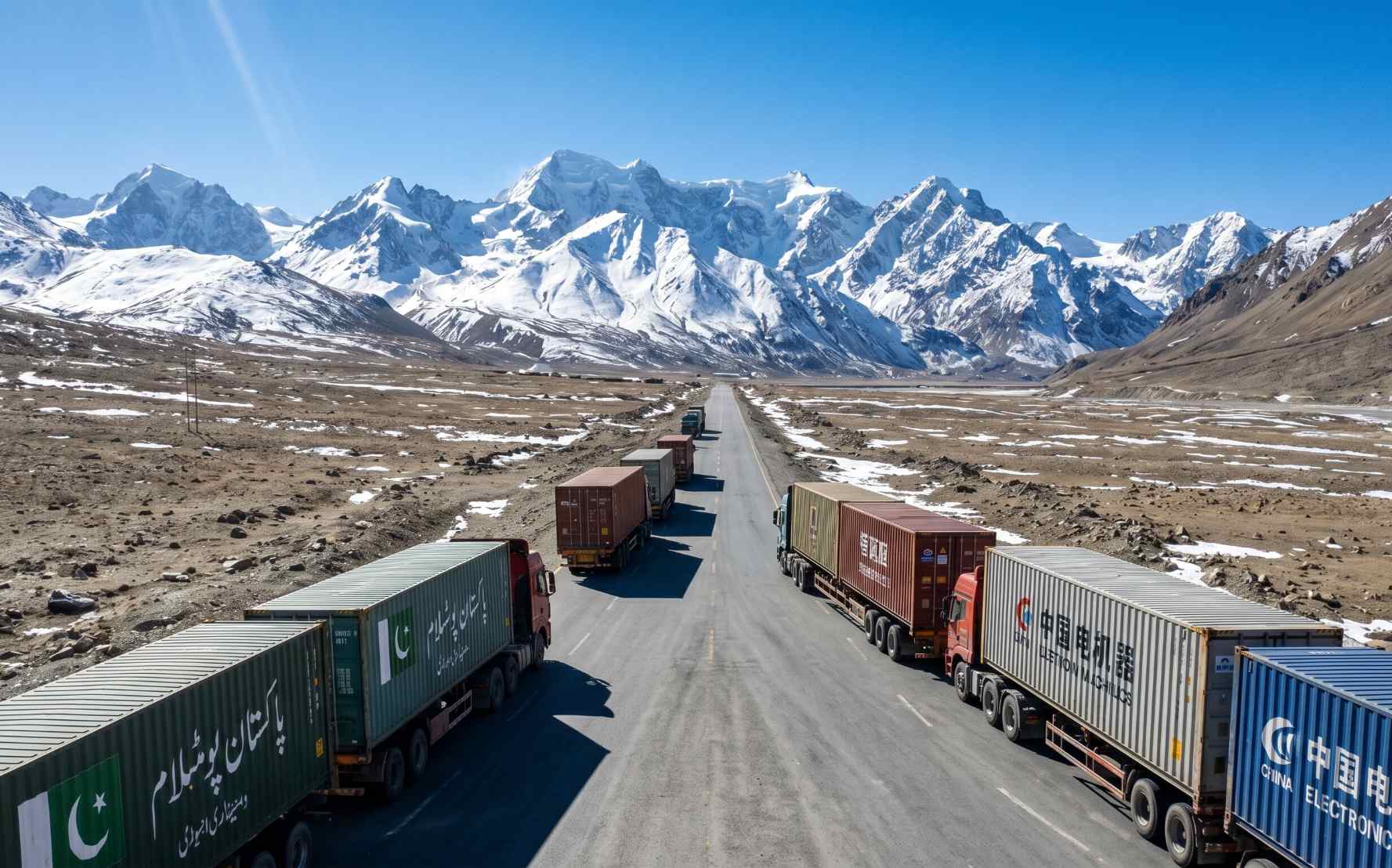
CPEC trade convoys on the Karakoram Highway. Since December 2024, the Khunjerab Pass has operated year-round for the first time, significantly boosting Pakistan-China overland trade
Visiting the Pakistan-China Border as a Tourist
The Khunjerab Pass is open to tourists visiting from the Pakistani side, and visiting the pass is one of the most iconic experiences available on any journey through Hunza and Gilgit-Baltistan. You do not need to cross into China to visit the pass itself. Many travellers drive from Passu or Sost to the border gate, take photographs at the boundary marker, experience the extraordinary high-altitude landscape, and return to Hunza the same day or following morning.
| Detail | Information |
|---|---|
| Location | Khunjerab Pass, Hunza-Nagar district, Gilgit-Baltistan. 75 km north of Sost, 270 km north of Gilgit, 870 km from Islamabad. |
| Elevation | 4,693 metres (15,397 feet) above sea level. |
| Best Season for Tourists | May to October. Roads are clearest June through September. Winter visits (November to April) are possible for Pakistani citizens but road conditions are severe above Sost. |
| Required Documents | Pakistani citizens: CNIC required. Foreign nationals: passport required. Entry into Khunjerab National Park requires payment of entry fee at Dih checkpoint. |
| Crossing Into China | Requires a valid Chinese visa obtained in advance. Cannot be obtained on arrival. The border is open Monday to Friday only. Pakistani and Chinese immigration are handled at Sost and Tashkurgan respectively (not at the gate itself). |
| Altitude Warning | At 4,693 metres, altitude sickness is a real concern. Acclimatise in Hunza for at least two days before attempting the pass. Carry water. Avoid overexertion at the top. |
| Distance from Hunza | Approximately 170 kilometres from Karimabad in Hunza Valley. Allow three to four hours each way on a good road day. |
| Transport | Private vehicle or hired jeep from Passu or Sost. NATCO and Hunza-Xinjiang buses operate for those actually crossing into China. Cycling is possible (many cyclists have ridden the full KKH) but bicycles must board the bus convoy for the China crossing. |
Altitude note: The Khunjerab Pass sits at 4,693 metres. Arriving here without proper acclimatisation after starting from Islamabad or Hunza can cause acute mountain sickness. Spend at least two nights in Hunza (2,500m) before attempting the drive to the pass. Symptoms including headache, nausea, and dizziness at altitude are not to be ignored. Descend immediately if symptoms are severe.
The Silk Road Legacy of the Pakistan-China Border
The route that the Karakoram Highway follows today is one of the most historically significant corridors in world history. The Silk Road, the network of trade routes connecting China to Central Asia, South Asia, Persia, and eventually Europe, was not a single road but a shifting web of paths through mountain passes and desert valleys. The Khunjerab route, along with the Mintaka and Kilik passes slightly to the west, was one of the high-mountain Silk Road branches that Buddhist monks, Chinese pilgrims, Sogdian traders, and Arab merchants used for over a thousand years to move between the Tang Dynasty of China and the kingdoms of the subcontinent.
The rock carvings at Chilas on the lower KKH document this traffic in extraordinary detail: thousands of inscriptions in Kharosthi, Brahmi, Sanskrit, Sogdian, Chinese, and Tibetan script carved by travellers and pilgrims over roughly 2,000 years, making them one of the world’s most remarkable open-air archives of Silk Road activity. Gandhara Buddhist pilgrims heading to China, Chinese monks returning from India with sacred texts, and Silk Road merchants marking their passage all left their names and prayers on the rocks above the Indus.
Today, the CPEC project explicitly frames itself as a revival of this ancient connectivity. Where silk and spices once moved by caravan, refrigerated trucks now carry Pakistani seafood to Kashgar. The geography has not changed. Only the vehicles have.
From the Crossroads team: Driving the Karakoram Highway from Islamabad to the Khunjerab Pass is one of the great journeys that Pakistan offers, and it is the natural culmination of any comprehensive visit to Hunza and Gilgit-Baltistan. The sense of arrival at the border gate, 4,693 metres above sea level, with the Karakoram rising in all directions and the knowledge that the same mountain corridor was walked by Silk Road merchants for a thousand years before the first car ever reached here, is genuinely moving. Our Hunza and Baltistan premium expedition includes the Khunjerab Pass as its northern horizon and the full KKH corridor as its spine.
Frequently Asked Questions
Where exactly is the Pakistan-China border?
Pakistan and China share a 523-kilometre border running through the Karakoram range in Gilgit-Baltistan. The border runs from the Wakhan Corridor in Afghanistan in the west to the disputed Siachen region in the east. The only official land crossing is the Khunjerab Pass at 4,693 metres above sea level on the Karakoram Highway, connecting Pakistan’s Upper Hunza to China’s Xinjiang Uyghur Autonomous Region.
What is the highest border crossing in the world?
The Khunjerab Pass on the Pakistan-China border at 4,693 metres above sea level is the highest paved international border crossing in the world. It sits on the Karakoram Highway in Gilgit-Baltistan and has been open to traffic since 1982. Since December 2024, it operates year-round for trade, having previously closed for the winter months due to severe snowfall and road conditions.
Can tourists visit the Khunjerab Pass without crossing into China?
Yes. Visiting the Khunjerab Pass from the Pakistani side does not require a Chinese visa or any intention to cross the border. Pakistani citizens need their CNIC and foreign nationals need their passport. The Khunjerab National Park entry fee must be paid at the Dih checkpoint. Tourists can drive to the border gate, take photographs, and return to Hunza or Sost the same day. The best season for this visit is June through September when roads are clear.
How long does it take to drive from Islamabad to the Khunjerab Pass?
The drive from Islamabad to the Khunjerab Pass covers approximately 870 kilometres on the Karakoram Highway and takes 14 to 18 hours of driving time depending on road conditions, stops, and the pace of travel. Most visitors break the journey over two to three days, stopping in Chilas or Gilgit on the first night and Hunza on the second before continuing to the pass. This pacing also allows for altitude acclimatisation, which is important before reaching the pass at nearly 4,700 metres.
What is CPEC and how does it relate to the Pakistan-China border?
The China-Pakistan Economic Corridor (CPEC) is a USD 65 billion infrastructure and development programme that connects China’s Xinjiang region to Pakistan’s Arabian Sea port of Gwadar via road, rail, energy projects, and special economic zones. The Karakoram Highway and Khunjerab Pass are the northern land anchor of CPEC, handling the overland movement of goods between the two countries. Since December 2024, the Khunjerab Pass has been open year-round for the first time, significantly increasing its trade capacity as a CPEC gateway.
What wildlife can you see near the Khunjerab Pass?
Khunjerab National Park, which surrounds the approach to the pass, is home to snow leopards, Marco Polo sheep, Siberian ibex, Himalayan brown bear, marmots, red foxes, the Eurasian lynx, and domesticated yaks herded by Wakhi communities at high altitude. The Marco Polo sheep, with their enormous spiralling horns, are the most distinctive large mammal of the Khunjerab plateau and can often be seen from the road. Snow leopards, while present in the park, are extremely rarely sighted given their elusive nature.
Drive to the Top of the World with Crossroads Adventure
The Karakoram Highway from Hunza to the Khunjerab Pass is one of the great road journeys on Earth. Crossroads Adventure builds it into every Hunza expedition as the natural northern horizon of the journey.
Plan Your Karakoram Highway Journey