No other country on Earth holds this combination. Pakistan contains five of the world’s fourteen eight-thousanders, more than 100 peaks above 7,000 metres, and the largest glacial system outside the polar regions. The fact that this mountain geography is less visited than comparable regions in Nepal or the European Alps makes it, for many serious travellers, the most compelling destination on the planet.
Crossroads Adventure was founded in the heart of this landscape, in Upper Hunza, and has been guiding international visitors through its ranges for over a decade. The full range of Pakistan expeditions and experiences available through Crossroads spans all three great ranges, from K2 Base Camp in the Karakoram to Tirich Mir in the Hindu Kush.
Why Pakistan’s Mountain Geography Is Unique
The mountain ranges of Pakistan were formed by one of the most powerful geological events in the history of the planet: the collision of the Indo-Australian tectonic plate with the Eurasian plate, a process that began around 55 million years ago and continues today. The force of that collision is what drove the Himalayas, Karakoram, and Hindu Kush upward to the extraordinary heights they hold, and it is what makes northern Pakistan one of the world’s most geologically active mountain zones.
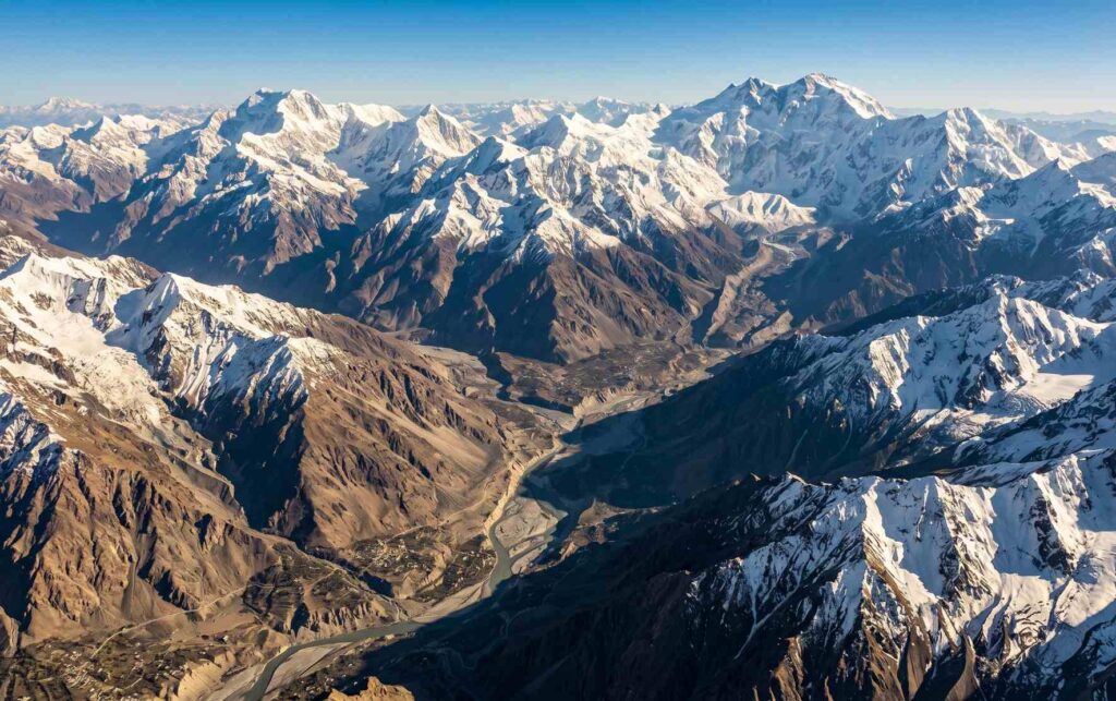
The point near Jaglot in Gilgit-Baltistan, approximately 40 kilometres south of Gilgit city, is where the Karakoram, the Himalayan system, and the Hindu Kush visibly converge. It is one of the most remarkable geographical confluences on Earth, a place where you can stand at a road viewpoint and understand, in a single glance, why this corner of the world has attracted geologists, mountaineers, and explorers for over 200 years.
The Karakoram: The World’s Second-Highest Mountain Range
The Karakoram is the dominant mountain range of Pakistan and the most concentrated area of high-altitude terrain anywhere on Earth. It stretches approximately 500 kilometres through Gilgit-Baltistan, straddling the borders of Pakistan, China, and India, with its greatest peaks and most extensive glaciation lying firmly within Pakistani territory.
The numbers associated with the Karakoram are difficult to absorb. It contains four of the world’s fourteen eight-thousanders: K2 (8,611m), Gasherbrum I (8,080m), Broad Peak (8,051m), and Gasherbrum II (8,035m). It has more than 60 peaks above 7,000 metres. Between 28 and 50 percent of its total area is glaciated, covering over 15,000 square kilometres, making it the most glaciated place on Earth outside the polar regions. The Siachen Glacier at 76 kilometres and the Biafo Glacier at 63 kilometres are the second and third longest glaciers in the world outside Antarctica and the Arctic.
K2: The Savage Mountain
K2 (8,611m) is the defining peak of the Karakoram and the second-highest mountain on Earth. It was named by the British surveyor Thomas Montgomerie in 1856 as the second peak of the Karakoram to be measured by the Survey of India. It is widely regarded among mountaineers as a more technically demanding and dangerous climb than Everest, earning it the nickname “the Savage Mountain.” The Baltoro Glacier route to K2 Base Camp is one of the great trekking journeys in the world, passing through the glacial amphitheatre of Concordia where four eight-thousanders are simultaneously visible.
Crossroads Adventure’s K2 Base Camp experience takes visitors through this extraordinary route with full professional guide support and comprehensive logistics. For those wanting to experience the wider Karakoram in a single journey, the South to North Pakistan heritage and mountain tour covers the range in remarkable depth.
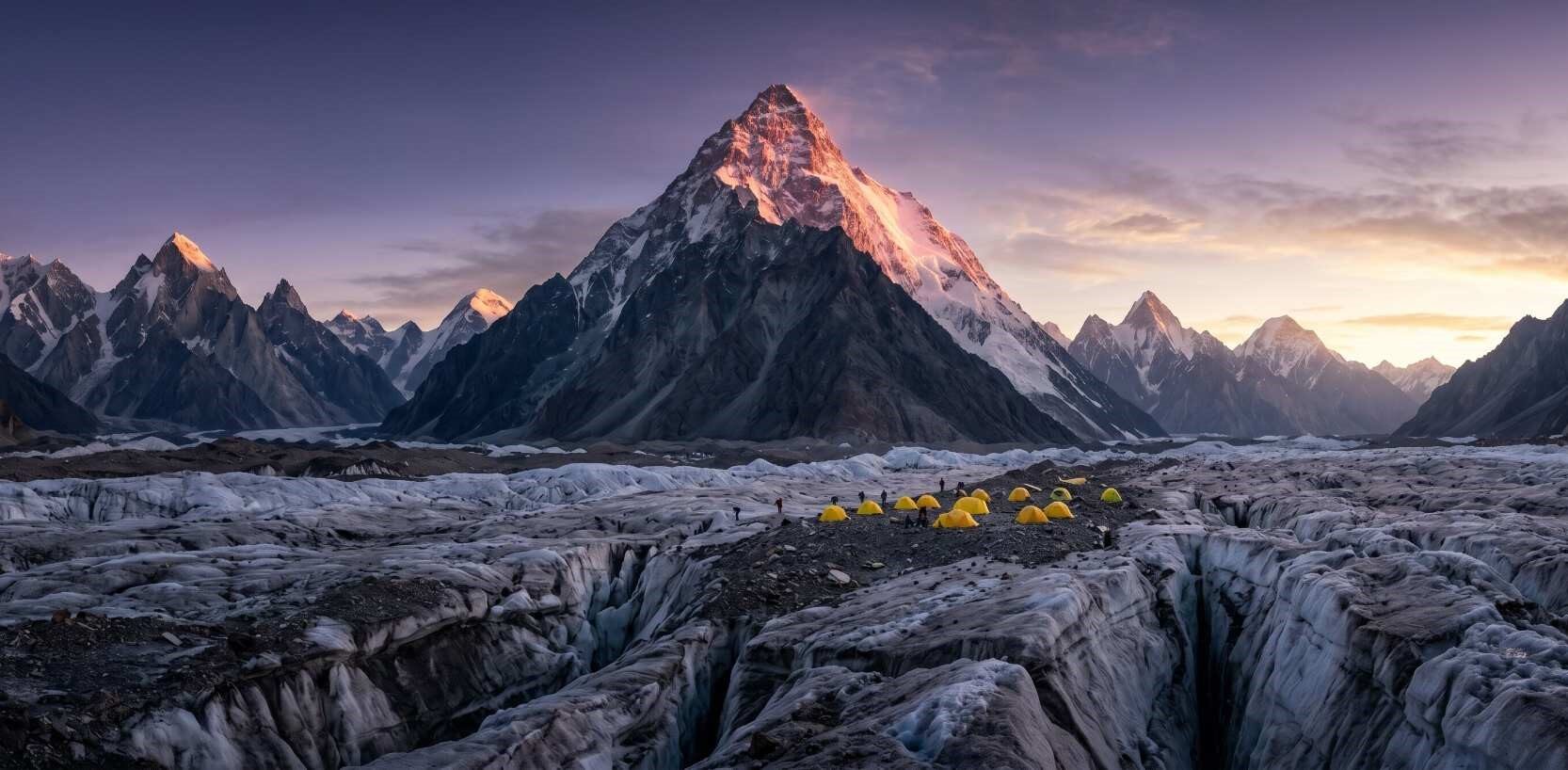
K2 at sunrise from the Baltoro Glacier. At 8,611 metres, it is the highest peak in the Karakoram and the second highest mountain on Earth
Key Karakoram Sub-Ranges and What They Contain
Baltoro Muztagh
The most celebrated sub-range, home to K2, Broad Peak, Gasherbrum I and II, and the Baltoro Glacier. This is where the greatest concentration of high mountaineering in the world takes place each summer.
Batura Muztagh
The westernmost major sub-range, visible above Passu in upper Hunza. Home to the Batura Glacier (57km) and a series of peaks including Batura I (7,795m). The Passu Cones rise dramatically from this sub-range.
Hispar Muztagh
Contains the Hispar Glacier and Snow Lake, the approach for one of the most demanding wilderness treks in the world. Connects via the Hispar Pass to the Biafo Glacier in Baltoro Muztagh.
Rakaposhi-Haramosh Range
Dominates the skyline above Hunza Valley. Rakaposhi (7,788m) is one of the most visually dramatic mountains in Pakistan, rising over 6,000 metres directly above the Hunza River gorge with almost no foothills.
| Peak | Height | Global Rank | Sub-Range | Expedition Access |
|---|---|---|---|---|
| K2 | 8,611m | 2nd | Baltoro Muztagh | Baltoro Glacier / Askole |
| Gasherbrum I | 8,080m | 11th | Baltoro Muztagh | Baltoro Glacier |
| Broad Peak | 8,051m | 12th | Baltoro Muztagh | Baltoro Glacier |
| Gasherbrum II | 8,035m | 13th | Baltoro Muztagh | Baltoro Glacier |
| Rakaposhi | 7,788m | 27th | Rakaposhi-Haramosh | Nagar Valley / Hunza |
| Batura I | 7,795m | 25th | Batura Muztagh | Upper Hunza / Passu |
The Western Himalayas: Pakistan’s Himalayan Reaches
The Himalayas are the world’s highest mountain system, stretching 2,400 kilometres from west to east across five countries. The western end of the chain enters Pakistan from Kashmir, and the section within Pakistan is referred to as the western or Pakistani Himalayas. This portion runs through Azad Kashmir, the Diamer and Gilgit districts of Gilgit-Baltistan, and the Hazara, Kohistan, Kaghan, and Naran regions of Khyber Pakhtunkhwa.
Unlike the central Himalayas, which sit east of the Indian subcontinent and are strongly influenced by the monsoon, the western Himalayas of Pakistan receive less monsoon rainfall and have a drier, more dramatic character, particularly in the upper elevations of Gilgit-Baltistan. The Karakoram Highway passes through the western Himalayan corridor before reaching Gilgit, cutting through gorges of extraordinary vertical depth.
Nanga Parbat: The Killer Mountain
Nanga Parbat (8,126m) is the ninth-highest mountain on Earth and the westernmost eight-thousander in the Himalayan chain. Its name comes from the Sanskrit “nanga parvata,” meaning “naked mountain,” while its local Shina name Diamir means “king of the mountains.” The peak earned the name “Killer Mountain” from its history of early mountaineering fatalities before the first successful summit in 1953.
Its north face, visible in full from Fairy Meadows at 3,300 metres, rises over 4,600 metres in a single sweep, making it one of the highest and most visually dramatic mountain faces anywhere in the world. The Rupal Face on the south is the tallest mountain face on Earth, rising 4,600 metres from base to summit. Crossroads Adventure’s Nanga Parbat Base Camp expedition and the Hunza and Fairy Meadows experience both bring visitors into direct contact with this extraordinary peak.
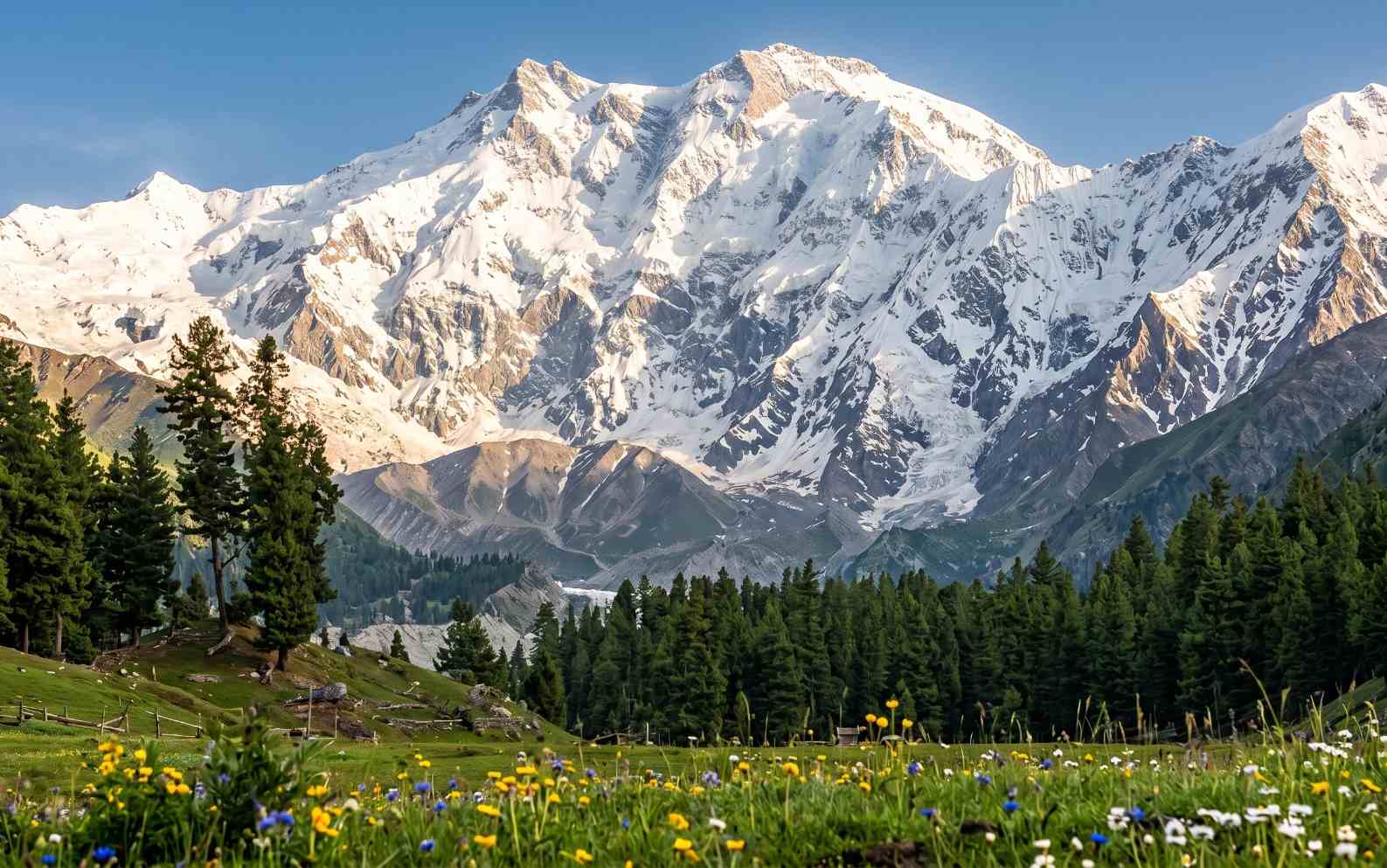
Nanga Parbat’s north face seen from Fairy Meadows. The mountain rises over 4,600 metres in a single continuous face, one of the greatest vertical rises in the world
Pakistan’s Western Himalayan Sub-Ranges
The Pakistani Himalayas are divided into four sub-ranges based on elevation and position. The Greater Himalayas (Central Himalayas in Pakistan) carry Nanga Parbat and the highest elevations in the Diamer and Gilgit districts. The Lesser Himalayas extend through Hazara, Kaghan, and Naran valleys, offering green alpine terrain accessible to visitors without high-altitude experience. The Pir Panjal range forms the southern wall of Kashmir. The Deosai Range surrounds the extraordinary Deosai plateau, the second-highest tableland in the world at an average elevation of 4,114 metres.
The Hindu Kush: The Third Great Range
The Hindu Kush stretches 800 kilometres from central Afghanistan through northwestern Pakistan into far southeastern Tajikistan. In Pakistan, the range occupies the Chitral district of Khyber Pakhtunkhwa and extends south through Dir, Swat, and Kohistan. Its eastern end merges with the Karakoram near the border of China, Pakistan, and Afghanistan, at the Pamir Knot, the geographical anchor from which all three of Pakistan’s great mountain systems radiate.
The Hindu Kush is culturally distinct from the Karakoram and Himalayas. The communities living within its valleys, including the Khowar-speaking Chitralis, the unique pre-Islamic Kalash people, and the Pashtun communities of Dir and Swat, have shaped a cultural landscape along these mountain corridors that is genuinely unlike anywhere else in South Asia. Historically, the Hindu Kush was a major corridor of the Silk Road and of conquest, with Alexander the Great and Timur among those who crossed its high passes.
Tirich Mir: The Roof of the Hindu Kush
Tirich Mir (7,708m) is the highest peak in the Hindu Kush range and the highest mountain in the world outside the Himalayan and Karakoram systems. It rises above Chitral town in a massive glaciated massif and was first summited in 1950 by a Norwegian team with Pakistani climbers. The trekking approaches to Tirich Mir from the Chitral valley pass through side valleys of exceptional beauty, green and forested at lower elevations, opening to wide moraines and glacial terrain above. Crossroads Adventure runs a dedicated Tirich Mir trekking expedition from Chitral.
From the Crossroads team: What makes the Hindu Kush exceptional for travellers is the combination of altitude, culture, and remoteness. Reaching Tirich Mir’s approaches means moving through Chitral town, through walnut and mulberry orchards, past Kalash villages, and into high valleys that see almost no international visitors. The mountain itself is remarkable. The journey to it is equally so.
Tirich Mir (7,708m) above Chitral Valley, the highest peak in the Hindu Kush and the tallest mountain outside the Karakoram and Himalayas
Pakistan’s Other Mountain Ranges
Beyond the three great ranges of the north, Pakistan contains several other notable mountain systems that shape its geography and offer their own landscapes and experiences.
The Hindu Raj
The Hindu Raj range sits between the Hindu Kush and Karakoram in northern Gilgit-Baltistan, running through Ghizar district. It is less celebrated than its neighbours but holds peaks exceeding 6,800 metres, including Koyo Zom (6,872m) at its highest point, and a series of remote valleys and glaciers rarely visited by international travellers. The range offers serious trekkers an opportunity to reach high terrain with minimal crowds.
The Sulaiman Range
The Sulaiman Range runs in a roughly north-south direction through Balochistan and parts of Punjab and Khyber Pakhtunkhwa. It is Pakistan’s most significant mountain system outside the northern ranges and reaches its highest point at Takht-e-Sulaiman (3,487m). The range holds strong cultural resonance for Pashtun communities and Sufi traditions, and it serves as the western edge of the Indus basin. According to local legend, both Solomon and Noah’s Ark have connections to its highest summit.
The Kirthar Range
The Kirthar Range runs along the eastern edge of Balochistan into Sindh and contains Sindh’s highest point, Barugh Hill, at 2,150 metres. It is the location of Kirthar National Park, one of Pakistan’s more accessible wildlife reserves, and the Gorakh Hill Station at 1,735 metres is sometimes described as the “Murree of Sindh” for its cool climate relative to the surrounding plains. The range lacks the scale of the northern systems but offers its own stark geological beauty.
The Salt Range
The Salt Range is geologically among the most ancient mountain formations in Pakistan, stretching through Punjab’s Chakwal, Jhelum, Mianwali, and Khushab districts between the Indus and Jhelum rivers. Its highest point, Sakesar, reaches only 1,522 metres, but the range is significant for the Khewra Salt Mine, the second largest salt mine in the world and a major tourist attraction in Punjab. The Salt Range contains rock formations of Precambrian age, making it a site of genuine geological importance.
| Mountain Range | Location | Highest Peak | Elevation | Key Feature |
|---|---|---|---|---|
| Karakoram | Gilgit-Baltistan | K2 | 8,611m | World’s 2nd highest range. 4 eight-thousanders. |
| Western Himalayas | GB, AJK, KPK | Nanga Parbat | 8,126m | World’s 9th highest peak. Includes Deosai plateau. |
| Hindu Kush | Chitral, KPK | Tirich Mir | 7,708m | Highest range outside Himalaya-Karakoram system. |
| Hindu Raj | Ghizar, GB | Koyo Zom | 6,872m | Remote range between Hindu Kush and Karakoram. |
| Sulaiman Range | Balochistan, Punjab | Takht-e-Sulaiman | 3,487m | Largest southern range. Strong Pashtun cultural ties. |
| Kirthar Range | Balochistan, Sindh | Barugh Hill | 2,150m | Kirthar National Park. Gorakh Hill Station. |
| Salt Range | Punjab | Sakesar | 1,522m | Ancient geology. Khewra Salt Mine (world’s 2nd largest). |
Trekking and Expeditions Across Pakistan’s Mountain Ranges
Pakistan’s mountain ranges between them offer every category of mountain experience, from accessible valley walks in the western Himalayas to the most technically demanding high-altitude climbing routes on Earth in the Karakoram. The key distinction for travellers planning an expedition is which range best matches their objectives, fitness, and available time.
The Karakoram suits those seeking the world’s highest and most dramatic terrain, with serious high-altitude routes requiring full expedition support. The western Himalayas offer a broader range of accessibility, from Fairy Meadows to Deosai. The Hindu Kush rewards those who value cultural depth alongside mountain grandeur.
Crossroads Adventure offers guided alpine treks and mountain expeditions across all three northern ranges, with itineraries ranging from the Rush Lake trek in Nagar Valley and the Shimshal Valley high passes expedition to the full K2 Base Camp journey on the Baltoro Glacier. For those who prefer the cultural depth of the Hindu Kush, the Hindu heritage expedition through Chitral combines mountain landscapes with the extraordinary traditions of the Kalash and Chitrali people.
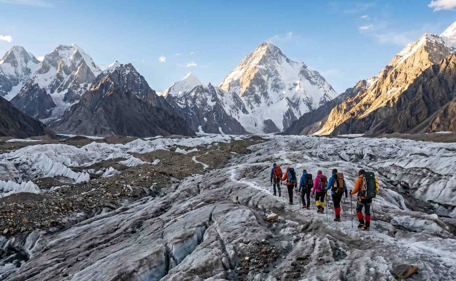
Trekkers on the Baltoro Glacier in Pakistan’s Karakoram range, surrounded by some of the highest mountains on Earth
Frequently Asked Questions
How many mountain ranges are in Pakistan?
Pakistan has seven significant mountain ranges. The three primary ranges of the north are the Karakoram, the western Himalayas, and the Hindu Kush. These are complemented by the Hindu Raj in northern Gilgit-Baltistan, and the Sulaiman, Kirthar, and Salt ranges in the south and central regions. The northern three ranges together contain the greatest concentration of high-altitude terrain found anywhere on Earth outside the polar regions.
Which is the highest mountain range in Pakistan?
The Karakoram is the highest mountain range in Pakistan and the second-highest mountain range in the world, after only the Himalayas when measured by average elevation of the highest peaks. It contains K2 (8,611m), Pakistan’s highest peak and the second-highest mountain on Earth, along with three other eight-thousanders and over 60 peaks exceeding 7,000 metres.
How many eight-thousanders are in Pakistan?
Pakistan contains five of the world’s fourteen eight-thousanders: K2 (8,611m) and Gasherbrum I (8,080m), Broad Peak (8,051m), and Gasherbrum II (8,035m) in the Karakoram, plus Nanga Parbat (8,126m) in the western Himalayas. Only Nepal contains more eight-thousanders, with eight of the fourteen lying within or on its borders.
Where do the three mountain ranges of Pakistan meet?
The Karakoram, western Himalayas, and Hindu Kush converge near Jaglot in Gilgit-Baltistan, approximately 40 kilometres south of Gilgit city at the confluence of the Indus and Gilgit rivers. This is considered one of the most remarkable geographical confluences on Earth. The Karakoram Highway passes through this area, and the convergence is visible from the road.
What are the biggest glaciers in Pakistan’s mountain ranges?
The Karakoram holds the world’s largest glacial system outside the polar regions. The Siachen Glacier (76km), Biafo Glacier (63km), and Baltoro Glacier are among the longest. The Batura and Hispar glaciers in Upper Hunza are also among the longest outside Antarctica and the Arctic. Chitral in the Hindu Kush holds over 500 glaciers of its own, including the Chiantar at 36 kilometres.
Can I trek in Pakistan’s mountain ranges as a non-technical hiker?
Yes. Many of Pakistan’s most spectacular mountain landscapes are accessible to trekkers without technical mountaineering skills. Fairy Meadows beneath Nanga Parbat, Rush Lake in Nagar Valley, Patundas Ridge in Upper Hunza, Deosai National Park, and the Tirich Mir trekking approaches in Chitral are all achievable with good physical fitness and proper guidance. Routes in the Karakoram such as K2 Base Camp and Shimshal high passes require more stamina and expedition support, but remain non-technical for qualified trekkers. Crossroads Adventure tailors every itinerary to the fitness level and objectives of each group.
What is the best time to visit Pakistan’s mountain ranges?
June through August is the primary season for high-altitude routes in the Karakoram and western Himalayas, with July being optimal for the K2 Base Camp route. The Hindu Kush and lower valley routes open from May through September. April in Hunza brings cherry blossom season. October is spectacular for autumn colour in the Karakoram valleys. Each season offers something genuinely distinct, and the right time depends on your specific route and objectives.
Explore Pakistan’s Mountain Ranges with Crossroads Adventure
From the glaciers of the Karakoram to the cultural valleys of the Hindu Kush, Crossroads Adventure builds expeditions that put you inside these landscapes with the professional guidance, local depth, and safety protocols that make the difference.
Start Planning Your Mountain Expedition