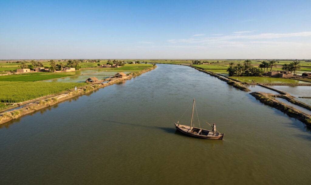
The rivers of Pakistan belong to one of the great river systems of the world. The Indus River Basin covers nearly one million square kilometres across Pakistan, India, China, and Afghanistan, with almost all of the basin’s water ultimately flowing through Pakistan to the Arabian Sea. The Indus and its tributaries irrigate more farmland than any other single river system in the world and have supported continuous agricultural civilisation in the Punjab and Sindh for at least 5,000 years.
Understanding Pakistan’s rivers is to understand Pakistan itself: its geography, its food supply, its historical cities, its ongoing water disputes with India, and the ancient trade routes and cultures that grew up along its banks.
Pakistan’s Major Rivers at a Glance
| River | Length in Pakistan | Originates In | Flows Through | Joins |
|---|---|---|---|---|
| Indus | 2,749 km | Tibet (Kailash region) | Gilgit-Baltistan, KPK, Punjab, Sindh | Arabian Sea near Karachi |
| Jhelum | 611 km (in Pakistan) | Verinag spring, Kashmir | AJK, Punjab (Jhelum, Gujrat) | Chenab at Trimmu |
| Chenab | 730 km (in Pakistan) | Bara Lacha Pass, Himachal Pradesh | Punjab (Gujranwala, Jhang, Multan) | Sutlej to form Panjnad |
| Ravi | 680 km (in Pakistan) | Dhauladhar Range, Himachal Pradesh | Punjab (Lahore corridor) | Chenab |
| Sutlej | 530 km (in Pakistan) | Rakshastal Lake, Tibet | Southern Punjab (Bahawalpur) | Chenab to form Panjnad |
| Kabul | ~320 km (in Pakistan) | Unai Pass, Afghanistan | KPK (Peshawar Valley) | Indus at Attock |
| Neelum (Kishanganga) | ~200 km (in AJK) | Kashmir Valley | Azad Kashmir (Neelum Valley) | Jhelum at Muzaffarabad |
| Swat | ~240 km | Hindu Kush, KPK | Swat Valley, KPK | Kabul River |
| Zhob | ~400 km | Toba Kakar Range, Balochistan | Balochistan | Gumal River |
The Indus River: Pakistan’s Lifeline
The Indus is the river on which Pakistan is built. Its name comes from the Sanskrit word sindhu, meaning ocean or great water, from which the words Sindh, Hindu, and India all derive. It originates in the Kailash region of Tibet at an elevation of over 5,000 metres, flows northwest through the Ladakh plateau, enters Pakistan’s Gilgit-Baltistan territory through the Karakoram, curves dramatically through the mountain gorges of the north, receives the waters of the Kabul River at Attock, crosses the Punjab plains absorbing its five great tributaries, and finally enters Sindh where it slows, widens, and braids across a flat plain before emptying into the Arabian Sea through a 200-kilometre-wide delta south of Karachi.
The Indus is at its lowest level in February, when the Himalayan and Karakoram snowfields are at their most frozen. It peaks in June through September, swollen by snowmelt and monsoon rainfall, when it can spread several kilometres wide across the Sindh plain. The river carries an enormous load of silt from the mountains, and most of Sindh’s flat agricultural plain is built from millennia of Indus alluvium deposited as the river slowed approaching the sea. This silt-built plain is among the most fertile agricultural land in South Asia.
The Indus gave the world the Indus Valley Civilisation, one of the three earliest urban societies in human history. Mohenjo-daro and Harappa, both within the Indus basin, were among the largest cities on Earth when they flourished around 2500 BC. The Indus gave India its name, Alexander the Great his eastern limit, and the British Empire its most productive colonial territory. Today it gives Pakistan 90 percent of its irrigated farmland and the water security of over 220 million people. Crossroads Adventure’s Indus Valley Civilisation expedition follows the river’s course through the archaeological sites that document the earliest civilisation it nurtured.
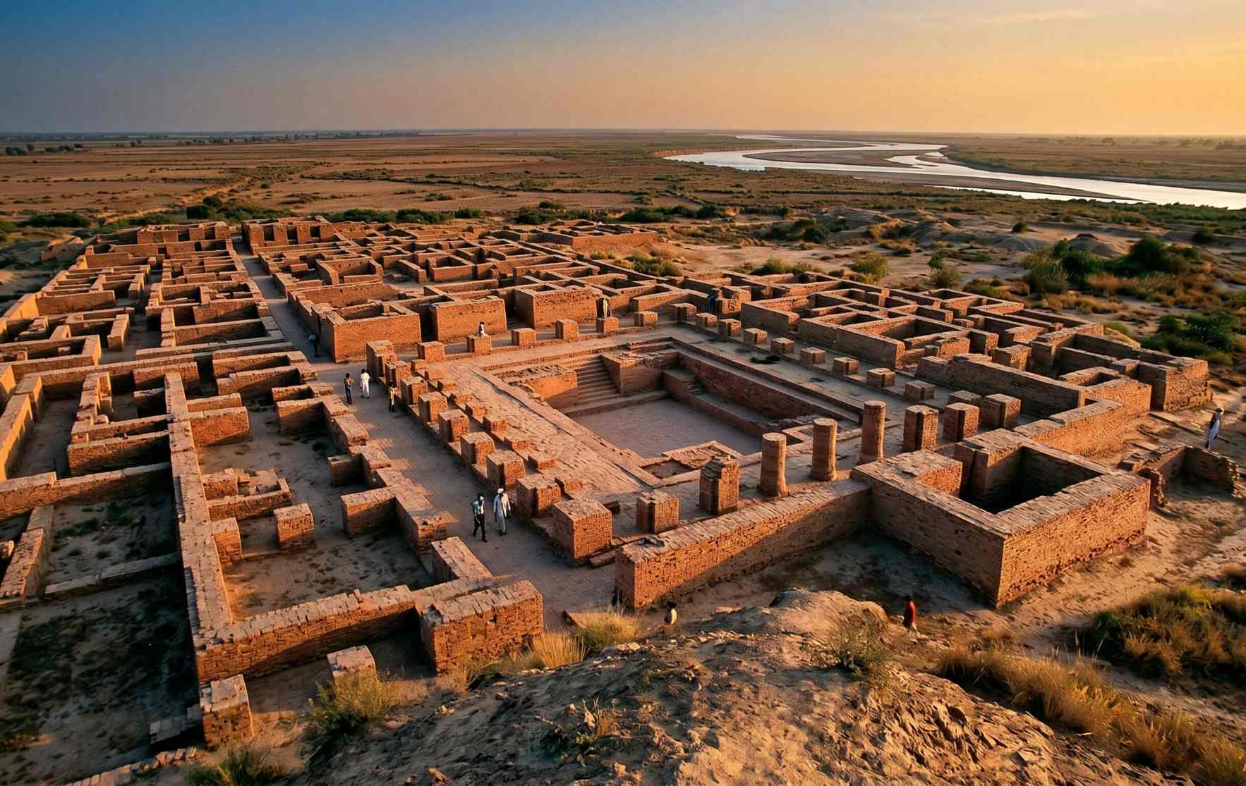
Mohenjo-daro in Sindh, built beside the Indus around 2500 BC. The river that gave this ancient city life is the same one irrigating Pakistan’s fields today
The Five Rivers of Punjab
Punjab means “the land of five waters” in Persian, a name given to the region because five rivers flow through it: the Jhelum, Chenab, Ravi, Beas, and Sutlej. These five rivers are the tributaries that fill the Indus on its left bank as it crosses from the north into the plains, and they define the geography, agriculture, and history of Pakistan’s most populous province more completely than any other geographical feature.
The Jhelum River
The Jhelum is the westernmost of the five Punjab rivers and the one most deeply embedded in Pakistani history and literature. It originates from the Verinag spring in the southeastern Kashmir Valley, flows north through Srinagar and Wular Lake, then turns sharply south at Muzaffarabad, forming the boundary between Indian and Pakistani administered Kashmir for 170 kilometres before entering Punjab proper at Mirpur. The Jhelum is known in Kashmir as the Vyath, from the Sanskrit Vitasta, one of the ten rivers mentioned in the Rigveda.
It was on the banks of the Jhelum in 326 BC that Alexander the Great fought the Battle of the Hydaspes against King Porus of the Paurava kingdom, the last major pitched battle of Alexander’s Indian campaign. The battle was hard-fought despite Alexander’s victory, and it was shortly after, when his army refused to advance further east, that Alexander turned back toward the west. The Jhelum was the eastern limit of the ancient world’s greatest military campaign. Mangla Dam, built on the Jhelum at Mirpur in 1967, is Pakistan’s second largest reservoir and a major source of both irrigation water and hydropower for Punjab and Azad Kashmir.
The Chenab River
The Chenab is formed from two headwaters, the Chandra and Bhaga rivers, originating on opposite sides of the Bara Lacha Pass in the Lahaul-Spiti region of the Himalayas. It enters Pakistan through the Jammu region, crosses the Punjab plains, and ultimately receives the waters of the Jhelum and Ravi before joining the Sutlej to form the Panjnad River. It is the largest of the five Punjab rivers by water volume and the longest entirely within Pakistan’s share of the Indus Waters Treaty.
The Chenab was known as Asikni in the Rigveda and Chandrabhaga in the Mahabharata. In the medieval period, the Chenab was the setting for the tragic legend of Heer and Ranjha, one of the great love stories of Punjabi literature, set in the village of Jhang on its banks. The river features throughout Punjabi folk poetry and music as a symbol of longing and separation, its waters between two lovers becoming a recurring metaphor in the literary tradition of the region. Pakistan has the exclusive right to use the Chenab’s waters under the Indus Waters Treaty of 1960.
The Ravi River
The Ravi originates in the Dhauladhar Range in Himachal Pradesh and flows through Chamba before entering Punjab and eventually Pakistan. It passes along the western edge of Lahore, the city that grew and flourished on its banks for centuries, and joins the Chenab further downstream. The Ravi was known as Iravati in Sanskrit and Hydraotes to the ancient Greeks who encountered it during Alexander’s campaign.
The Ravi’s story in modern Pakistan is a complicated and somewhat melancholy one. Under the Indus Waters Treaty of 1960, the Ravi, along with the Beas and Sutlej, was allocated to India as an eastern river. Pakistan retained the western rivers: the Indus, Jhelum, and Chenab. As India progressively developed upstream barrages and diversion projects on the Ravi, the river’s flow into Pakistan diminished significantly over the decades. By the time it reaches Lahore today, the Ravi carries only a fraction of the water that once made it a broad, navigable river and the lifeblood of the city beside it. In March 2025, India formally stopped the flow of Ravi water into Pakistan after completing the Shahpur Kandi Barrage, a development that has added to existing tensions around the Indus Waters Treaty.
Lahore’s historic relationship with the Ravi is everywhere in the city’s cultural landscape. The Mughal tomb of Emperor Jahangir and his wife Noor Jahan stands at Shahdara Bagh on the Ravi’s banks. The city’s oldest Mughal gardens were designed to draw from the river. The Ravi is part of Lahore’s identity in the way that the Thames is part of London’s, even as the river itself has diminished. Crossroads Adventure’s Mughal heritage trail through Lahore passes directly through this riverine cultural landscape.
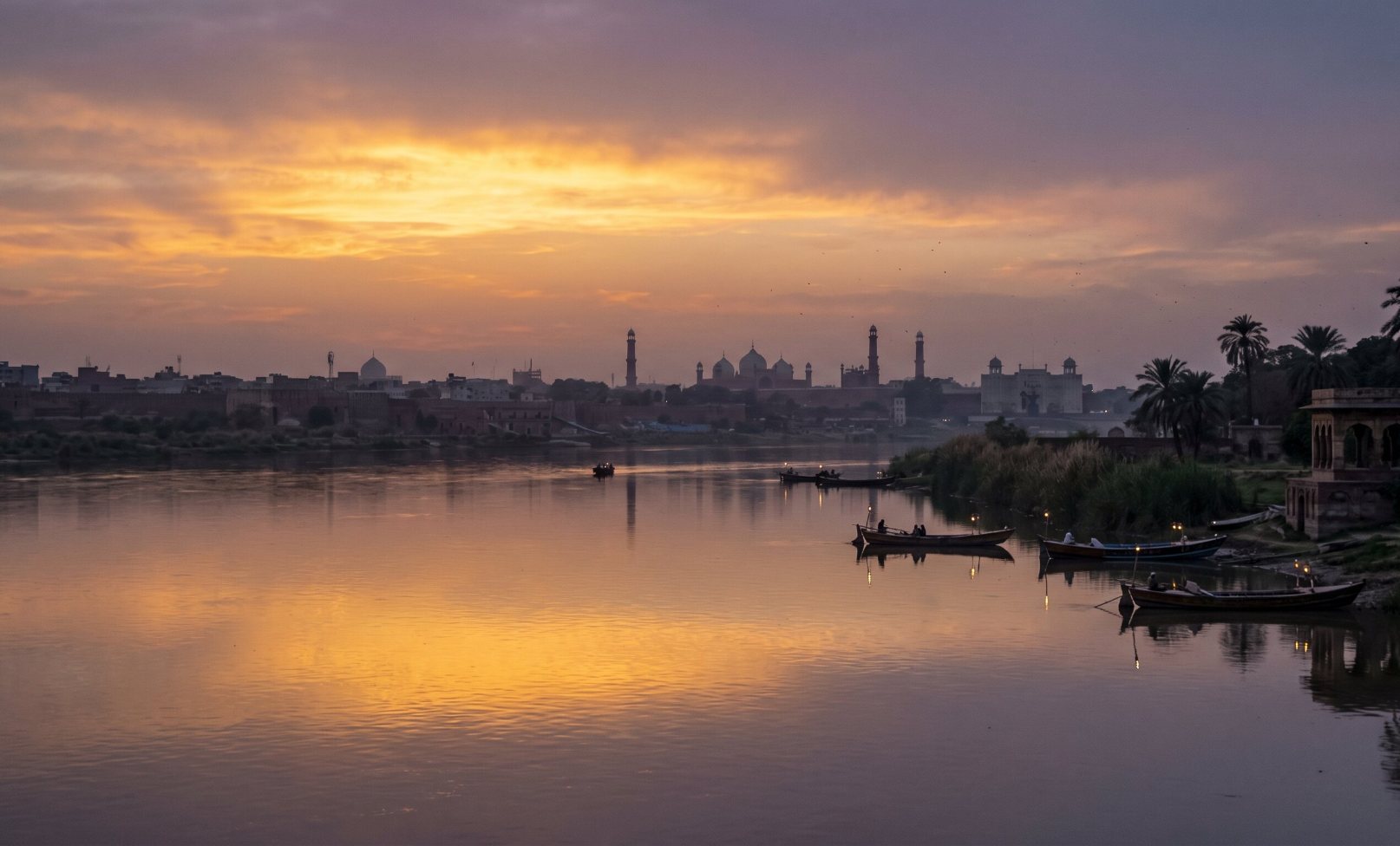
The Ravi River at Lahore at dusk. The river that once defined Lahore’s geography and fed its Mughal gardens has diminished significantly since the Indus Waters Treaty allocated it to India
The Sutlej River
The Sutlej is the longest of the five Punjab rivers, originating in Tibet near Rakshastal Lake in the Kailash-Mansarovar region and flowing westward through India before crossing into Pakistan’s southern Punjab near Bahawalpur. It is the easternmost of the five rivers and in Sanskrit was known as Shatadru, meaning “hundred rivers,” a reference to the many channels it divides into across the flat plains. Like the Ravi, the Sutlej was allocated to India under the Indus Waters Treaty and its flow into Pakistan has been substantially reduced by Indian upstream development. The Sutlej joins the Chenab at Uch Sharif in southern Punjab to form the Panjnad River, the combined stream of all five Punjab rivers that flows into the Indus at Mithankot.
The Panjnad: Where Five Rivers Become One
The Panjnad River, whose name comes from Persian panj (five) and Sanskrit nadi (river), is formed at the successive confluence of all five Punjab rivers near Uch Sharif in the Muzaffargarh district. The Jhelum and Ravi first join the Chenab at Trimmu. The Beas joins the Sutlej. Then the Sutlej and Chenab merge near Uch Sharif to create the Panjnad. This combined stream flows approximately 72 kilometres before joining the Indus at Mithankot, after which the now greatly swollen Indus continues its final journey southward through Sindh to the sea. The ancient name for the Indus below this point was Satnad, meaning “seven rivers,” reflecting the waters of the Indus itself and the six tributaries it had absorbed by this point.
Other Major Rivers of Pakistan
The Kabul River
The Kabul River originates in Afghanistan near the Unai Pass west of Kabul city and flows eastward through Nangarhar province in Afghanistan before crossing into Pakistan’s Khyber Pakhtunkhwa. It passes through the Peshawar Valley, one of the most historically significant plains in South Asia, absorbing several tributaries including the Swat, Kunar, and Bara rivers before joining the Indus at Attock in Punjab. The Kabul River corridor is the ancient gateway between Central Asia and the Indian subcontinent, the route through which Alexander the Great, Timur, Babur, and countless others crossed from Afghanistan into the subcontinent. Peshawar, on its banks, is one of the oldest continuously inhabited cities in South Asia and the cultural heart of the Pashtun world.
The Swat River
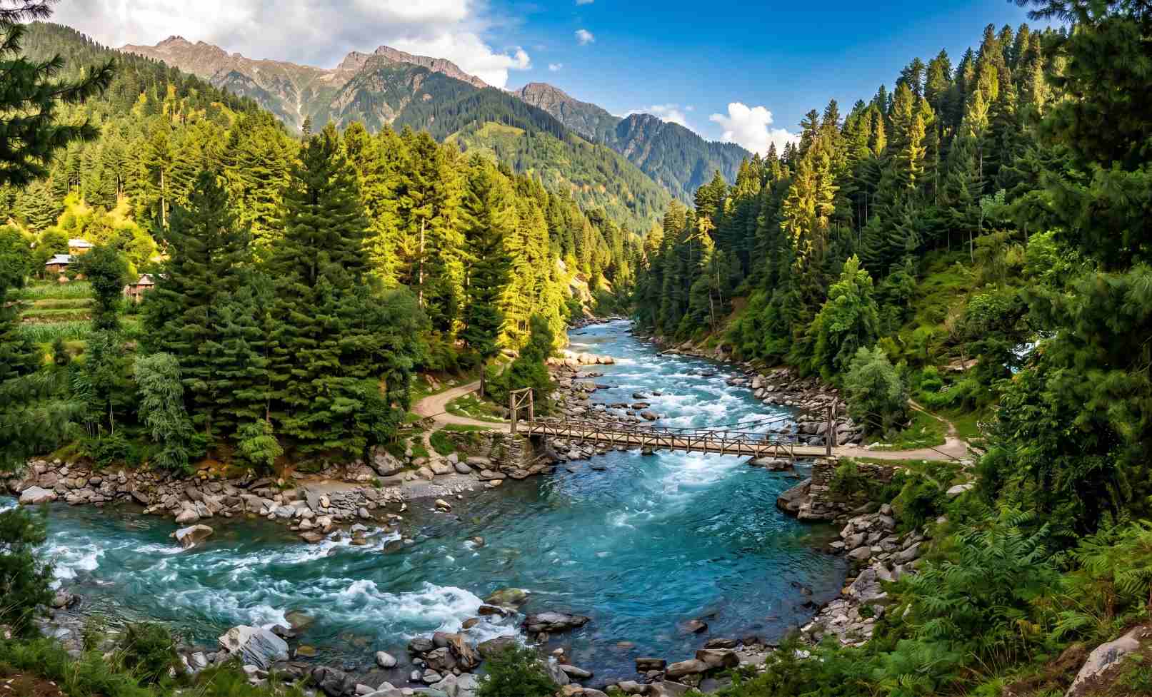
The Swat River flows southward through the famous Swat Valley in Khyber Pakhtunkhwa before joining the Kabul River. Fed by glaciers and snowmelt in the Hindu Kush, it is clear, fast, and cold through most of its course, and its valley is one of the most fertile and beautiful in Pakistan. The Swat Valley that lines its banks was the heartland of the ancient Gandhara civilisation, the same cultural zone that produced the extraordinary Greco-Buddhist art of the Taxila and Takht-i-Bahi sites. The river is famous for its trout population, and fishing the Swat and its tributaries has been a distinctive local tradition for generations.
The Neelum River (Kishanganga)
The Neelum River, known as Kishanganga on the Indian side of the Line of Control, flows through the extraordinary Neelum Valley in Azad Kashmir before joining the Jhelum at Muzaffarabad. The Neelum Valley is named for the river: neelum means sapphire in Urdu, and the river’s vivid blue-green glacial colour through the valley’s forests and meadows earns the name completely. The valley it cuts is home to some of the finest high-altitude lakes in Pakistan, including Ratti Gali and the Shounter Valley lakes, and the river itself is fed by over 40 tributaries as it descends through the valley. Crossroads Adventure’s Kashmir alpine meadows and Ratti Gali experience moves through the Neelum Valley watershed, where the river and its tributaries define the landscape entirely.
The Rivers of Balochistan
Balochistan’s rivers are a different category altogether from the perennial rivers of Punjab and KPK. They are seasonal, fed by monsoon and winter rain rather than glacier melt, and most either drain into the Indus system via the Gumal River in the north or flow independently into the Arabian Sea in the south. The Zhob runs along the southern slopes of the Toba Kakar Range and joins the Gumal, which itself joins the Indus near Dera Ismail Khan. The Bolan flows through the Bolan Pass, the ancient and strategic route connecting the Indus plains to the Iranian plateau and Central Asia. In southern Balochistan, the Dasht, Mashkai, Nal, and Porali rivers flow independently to the Arabian Sea, cutting through the Makran coastal landscape before entering the ocean.
The Neelum River in Azad Kashmir, its sapphire colour giving the valley its name. The river feeds some of Pakistan’s finest glacial lakes before joining the Jhelum at Muzaffarabad
The Indus Waters Treaty: Sharing Pakistan’s Rivers with India
The partition of British India in 1947 divided the Indus River system between the new nations of India and Pakistan in a way that left Pakistan’s Punjab dependent on rivers whose headwaters ran through Indian territory. A complex and often bitter negotiation, mediated by the World Bank, eventually produced the Indus Waters Treaty, signed on 1 April 1960 by Indian Prime Minister Nehru and Pakistani President Ayub Khan.
The treaty divided the six main rivers of the system into two groups. India received exclusive rights to the three eastern rivers: the Ravi, Beas, and Sutlej. Pakistan received exclusive rights to the three western rivers: the Indus, Jhelum, and Chenab, which collectively carry around 80 percent of the total water in the system. India retained some limited rights to use the western rivers for power generation and non-consumptive purposes, and Pakistan was given a transition period to build replacement canal infrastructure before the eastern rivers were fully diverted.
For over 60 years, the Indus Waters Treaty survived three major Indo-Pakistani wars and multiple political crises, making it widely regarded as one of the most successful bilateral water-sharing agreements in the world. However, the treaty faces unprecedented pressure in the mid-2020s. India put the treaty in abeyance following a major security incident in 2025, and Pakistan’s Foreign Office has formally complained to India about sudden changes in the flow of the Chenab and Jhelum. Water, which has always been existentially important to Pakistan, has become the newest front in a long-running geopolitical relationship.
Why Pakistan’s rivers matter beyond agriculture: The rivers of Pakistan have built every major city in Punjab and Sindh. Lahore grew on the Ravi. Multan on the Chenab. Hyderabad and Sukkur on the Indus. They shaped the Silk Road trade routes through Peshawar’s Kabul River corridor and the Buddhist pilgrimage paths through the Swat Valley. They carried the boats of the Indus Valley Civilisation’s merchants and the fleets of Alexander’s retreating army. They are the reason Pakistan exists where it does, why its cities are where they are, and why its soil is as fertile as it is. The rivers are not background to Pakistan’s history. They are the story.
The Indus Delta and Pakistan’s Coastline
The Indus finishes its 3,180-kilometre journey in a broad, flat delta of approximately 17,000 square kilometres on the coast of Sindh, emptying into the Arabian Sea south of Karachi. The delta was once one of the most productive mangrove ecosystems in the world and a critical habitat for the Indus River dolphin, one of the world’s rarest freshwater dolphin species. Reduced river flow caused by upstream dams and irrigation diversions over the past century has significantly diminished both the mangrove coverage and the dolphin population.
The Indus Blind Dolphin, also known as the Bhulan, is found only in the lower Indus and its connected lakes. It is nearly completely blind, having evolved in the silty, low-visibility waters of the lower river, navigating entirely by sonar. Conservation efforts by the WWF Pakistan and the Sindh Wildlife Department have focused on protecting the remaining dolphin population, which numbers in the hundreds, and restoring some of the freshwater flow that the delta needs to function as a living ecosystem.
Pakistan’s Rivers in Culture, Poetry, and Identity
No understanding of Pakistan’s rivers is complete without acknowledging their place in the country’s cultural imagination. The rivers of Punjab have been the subject of Punjabi poetry and folk music for over a thousand years. The Ravi and Chenab appear constantly in the classical Punjabi love narratives, Heer Ranjha, Mirza Sahiban, and Sohni Mahiwal, as symbols of longing, separation, and the impossible distance between hearts. In these stories, rivers are not just geographical features. They are the agents of fate, the obstacles lovers must cross or drown trying to cross, the witnesses to everything that cannot be said directly.
The Indus itself carries one of the oldest documented names in the entire region, sindhu, a Sanskrit word that eventually gave India its name. It appears in the Rigveda, composed on or near its banks more than three thousand years ago. The river is older than the civilisations that named it, older than every historical event that has taken place within view of its banks, and it will continue flowing long after the current political maps of South Asia have been revised again.
Experiencing Pakistan’s rivers: Every journey through Pakistan crosses its rivers repeatedly. The Karakoram Highway follows the Indus for hundreds of kilometres through the mountain gorges of the north. The road from Islamabad to Lahore crosses the Chenab and Jhelum. A visit to Lahore includes the Ravi. A journey into Azad Kashmir follows the Neelum. And a visit to Sindh, where the Indus Valley Civilisation left its greatest monuments, is a journey along the very river that made those cities possible 4,500 years ago.
Frequently Asked Questions
What is the longest river in Pakistan?
The Indus is the longest river in Pakistan, running 2,749 kilometres within Pakistani territory alone and 3,180 kilometres in total from its source in Tibet. It flows the full length of the country from the mountains of Gilgit-Baltistan to the Arabian Sea delta in Sindh. The Indus also has the largest catchment area of any river in Pakistan, covering nearly one million square kilometres across Pakistan, India, China, and Afghanistan.
Why is Punjab called the Land of Five Rivers?
Punjab gets its name from two Persian words: panj meaning five and ab meaning water. The five rivers that flow through the Punjab region are the Jhelum, Chenab, Ravi, Beas, and Sutlej, all tributaries that join the Indus from the left bank as it crosses from the mountains into the plains. These five rivers gave the region unparalleled agricultural productivity and were the foundation of continuous civilisation in the Punjab for at least 5,000 years. They merge successively to form the Panjnad River, which joins the Indus at Mithankot.
What is the Indus Waters Treaty?
The Indus Waters Treaty is a water-sharing agreement signed in 1960 between India and Pakistan, mediated by the World Bank. It divided the six rivers of the Indus system between the two countries: India received the eastern rivers (Ravi, Beas, Sutlej) and Pakistan received the western rivers (Indus, Jhelum, Chenab), which carry approximately 80 percent of the total flow. The treaty survived three Indo-Pakistani wars and was regarded as one of the world’s most successful bilateral water agreements for over 60 years. It is currently under significant strain due to geopolitical tensions in the mid-2020s.
Where does the Indus River end?
The Indus ends in a broad delta of approximately 17,000 square kilometres on the coast of Sindh province, south of Karachi, emptying into the Arabian Sea. The delta was historically one of the most productive mangrove and wetland ecosystems in Asia, home to the rare Indus Blind Dolphin. Reduced river flow due to upstream dams and irrigation diversions over the past century has significantly diminished the delta’s ecological health and the volume of water reaching the sea.
Which river flows through Lahore?
The Ravi River flows through Lahore, or more precisely, past its western edge. The Ravi was central to Lahore’s historical development, and many of the city’s greatest Mughal monuments, including the Tomb of Jahangir and the Shalimar Gardens, were built in relation to the river. Under the Indus Waters Treaty of 1960, the Ravi was allocated to India, and its flow into Pakistan has been progressively reduced by Indian upstream development. The Ravi through Lahore today carries significantly less water than it did historically.
What is the cleanest river in Pakistan?
The rivers of northern Pakistan’s mountain regions, including the upper Swat, Neelum, and Kunhar, are among the cleanest in the country due to their remote source areas, low population density, and glacial or snowmelt origin. The Kunhar River in the Kaghan Valley and the Neelum in Azad Kashmir are particularly noted for the clarity and quality of their water. The major lowland rivers, including the Ravi through Lahore and the lower Chenab, carry significant pollution from industrial and agricultural runoff and are among the country’s most ecologically stressed water bodies.
Explore Pakistan Alongside Its Rivers
Every great journey through Pakistan follows a river. The Indus through Sindh. The Neelum through Azad Kashmir. The Swat through the Gandhara heartland. Crossroads Adventure builds cultural and heritage expeditions through the landscapes these rivers created.
Plan Your Pakistan River Journey