Most international visitors associate Pakistan with its mountain landscapes, and understandably so. But the country’s desert regions tell an entirely different story, one of ancient civilisations that thrived on the banks of rivers that have since gone dry, of nomadic communities that have moved their herds across the same dune systems for centuries, and of fortresses and caravanserais that mark the routes of traders who carried goods between the subcontinent, Central Asia, and the Persian world long before recorded history.
Pakistan’s deserts occupy Sindh, Punjab, Balochistan, and a unique cold desert in Gilgit-Baltistan. Each has its own climate, character, ecology, and cultural significance. This guide covers all five in full.
Pakistan’s Deserts at a Glance
1 cold
| Desert | Province | Area | Type | Key Feature |
|---|---|---|---|---|
| Thar (Tharparkar) | Sindh | ~175,000 km² (shared with India) | Subtropical hot desert | Largest in Pakistan. Only subtropical desert in Asia. Densely populated. |
| Cholistan (Rohi) | Punjab | ~26,300 km² | Hot arid desert | Derawar Fort, Cholistan Jeep Rally, ancient Hakra River civilisation. |
| Thal | Punjab | ~15,000 km² | Semi-arid | Between Indus and Jhelum rivers. Significant irrigation development. |
| Kharan | Balochistan | ~20,000 km² | Hot arid and mountainous | Extremely remote. Pakistan’s nuclear test site. Iranian border region. |
| Katpana (Cold Desert) | Gilgit-Baltistan | Small | Cold high-altitude desert | Snow-covered sand dunes at 2,200m. Near Skardu. |
The Thar Desert: Pakistan’s Largest and Most Vibrant Desert
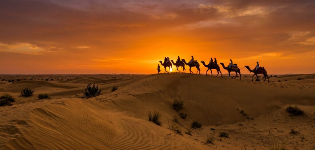
The Thar Desert spans southeastern Sindh and crosses into the Indian state of Rajasthan, making it the world’s 16th largest desert overall and the only major subtropical desert in Asia. In Pakistan, it is known primarily as Tharparkar, after the district it dominates. What sets the Thar apart from virtually every other desert in the world is its population density: despite extreme summer temperatures reaching 50°C and annual rainfall below 200 millimetres in most areas, the Thar supports one of the most densely inhabited desert landscapes on Earth, with communities living in a balance with the desert environment refined over thousands of years.
The landscape shifts from rolling golden dunes in the west, the classic Thar image, to flat rocky terrain and occasional shallow lakes in the east. In the monsoon months of July and August, rain transforms the Thar briefly into a green, flowering landscape, after which the desert quickly reasserts itself. The Rann of Kutch, a vast seasonal salt marsh, forms the Thar’s southern boundary near the Indian border.
Culture and Heritage of the Thar
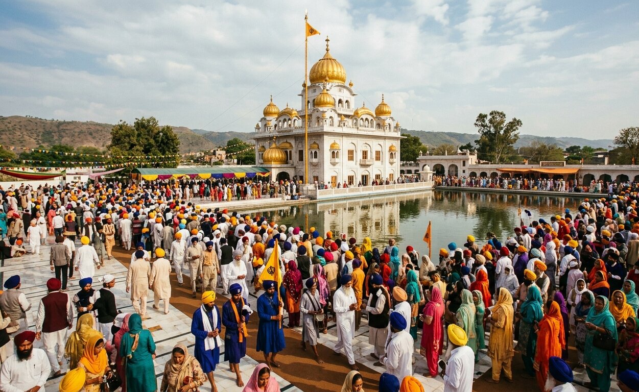
The Thar is one of Pakistan’s most culturally extraordinary regions. The Sindhi communities of Tharparkar have maintained traditions of embroidery, music, folk poetry, and religious practice that connect directly to the pre-Islamic civilisations of the Indus Valley. Thari embroidery, using geometric patterns and vivid colours on fabric, is among the most celebrated textile traditions in Sindh. The folk music of the Thar, including the plucked Sindhi sarangi and the ektaro drone instrument, carries an oral literary tradition stretching back centuries. The desert is also home to significant Hindu and Jain religious sites, making Tharparkar one of the few districts in Pakistan where Hindu pilgrimage traditions remain actively practiced by a substantial local population.
Umarkot, at the edge of the Thar near the Indian border, is the birthplace of the Mughal Emperor Akbar, born here in 1542 when his father Humayun was in exile. The Umarkot Fort, dating to the same era, remains the most significant historic monument in the Thar. The Indus Valley Civilisation expedition and the Southern Pakistan and Punjab heritage tour by Crossroads Adventure both move through this region’s extraordinary historical record.
Wildlife of the Thar
Despite its extreme conditions, the Thar supports a remarkable range of wildlife. The chinkara (Indian gazelle), one of the most graceful desert antelopes in South Asia, is found across the dunes. Desert foxes, Indian grey wolves, monitor lizards, and numerous species of snake, including the saw-scaled viper, all inhabit the desert ecosystem. The Thar is famous for its bird life, including the Indian peacock (Pakistan’s national bird in terms of cultural significance, though not officially designated), houbara bustard, grey francolin, and numerous migratory species that use the desert as a staging post during winter migration along the Indus flyway. The Great Indian bustard, one of the most critically endangered birds in South Asia, once ranged across Tharparkar and is still occasionally sighted.
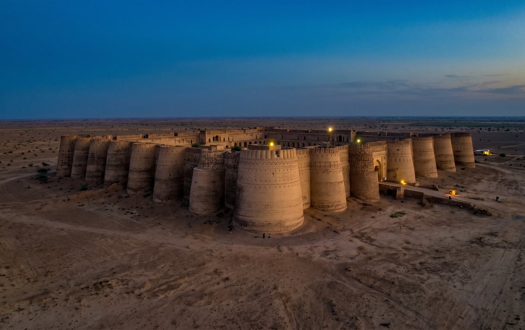
Derawar Fort in the Cholistan Desert, Punjab, one of the finest and best-preserved desert fortresses in South Asia, 130 kilometres south of Bahawalpur
The Cholistan Desert: History Written in Sand
Cholistan, known locally as Rohi, is the desert of southern Punjab, stretching from the periphery of Bahawalpur city southward to the Sindh border and eastward into Indian Rajasthan. Its name is thought to derive from the Turkic word chol, meaning desert or wilderness. The landscape is a mix of shifting sand dunes, flat sandy plains, and the occasional toba, a natural or man-made depression that collects rainwater and becomes the lifeline of nomadic communities who have moved across this desert for centuries.
What makes Cholistan historically extraordinary is what lies beneath its sand. The ancient Hakra River, which flowed through what is now Cholistan and fed one of the densest concentrations of Indus Valley settlements ever documented, dried up around 2000 BC when its water source shifted. The result is a desert that contains the buried remains of hundreds of ancient settlements, many still unexcavated. Cholistan was, in other words, once a thriving agricultural civilisation, and the desert itself is a monument to climate change on a historical timescale.
Derawar Fort
The defining monument of the Cholistan is Derawar Fort, located 130 kilometres south of Bahawalpur at the heart of the desert. Built and rebuilt over many centuries, the fort reaches its current form under the Nawabs of Bahawalpur, who restored and expanded it in the 18th and 19th centuries. It is one of the finest preserved desert fortresses in South Asia: a square structure with 40 perfectly symmetrical bastions, walls rising 30 metres above the desert floor, and the adjacent Abbasi mosque and royal tombs completing a monumental desert complex of genuine architectural quality. The fort’s remoteness in the desert gives it a quality of isolation that no photograph fully captures.
The Cholistan Jeep Rally
The annual Cholistan Desert Jeep Rally, held in February, is one of the most celebrated motorsport events in Pakistan and one of the largest jeep rallies in Asia. Teams from across Pakistan and internationally race modified jeeps across the desert landscape for three days, drawing large crowds to Bahawalpur and the desert’s edge. The rally has become a significant event for cultural tourism in Punjab, combining competitive motorsport with the extraordinary desert scenery, local food, camel rides, and craft markets that accompany it.
The Semi-Nomadic People of Cholistan
The Cholistan is home to semi-nomadic communities who move their herds of camels, cattle, sheep, and goats across the desert following seasonal rain and pasture. The desert’s economy is built on livestock, with Cholistan’s rangelands capable of supporting up to two million head of cattle at capacity. The community crafts of Cholistan, including hand-woven blankets and rugs, beautifully embroidered Cholistani khussas (traditional shoes), and gold and silver jewellery, represent a cottage industry tradition entirely distinct from the urban craft traditions of Punjab’s cities. Crossroads Adventure’s Southern Pakistan and Punjab heritage journey covers the Cholistan and Bahawalpur region as part of a wider sweep through the country’s most overlooked historical landscape.
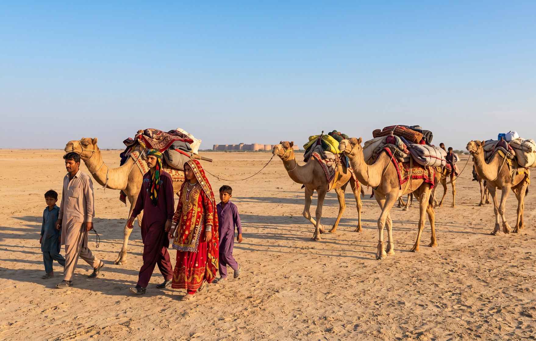
Semi-nomadic communities of Cholistan have moved their camel and cattle herds across the same desert corridors for centuries, following seasonal rain and pasture
The Thal Desert: The Desert That Became Farmland
The Thal Desert occupies the Sindh Sagar Doab, the landmass between the Indus River to the west and the Jhelum and Chenab rivers to the east, in central Punjab. Running approximately 300 kilometres from north to south and between 50 and 190 kilometres wide at various points, Thal is the most heavily modified of Pakistan’s deserts. The construction of the Jinnah Barrage on the Indus at Kalabagh in 1946 and the Thal Canal system that followed began a transformation of parts of the desert into irrigated farmland that has continued ever since.
Unlike the Thar and Cholistan, the Thal is classified as semi-arid rather than full desert, with seasonal rainfall and a less extreme temperature range. Sand dunes exist but are less dramatic than the classic dune fields of the Thar. The real character of Thal is in its gradual transformation from empty sandy wastes to productive agricultural land at its irrigated margins, and the persistence of genuinely arid conditions in its core. The north of Thal borders the Salt Range, the ancient geological formation whose Khewra Salt Mine is one of the world’s largest salt deposits.
The Thal desert communities maintain a distinct folk tradition known as the Thali dialect, alongside traditional folk dances and livestock herding practices. Mankera Fort, a Mughal-era structure in Bhakkar district, is the most significant historical monument within the Thal landscape.
The Kharan Desert: Balochistan’s Remote and Rugged Wilderness
The Kharan Desert in western Balochistan is among the most remote and least visited of Pakistan’s desert landscapes. Bounded by mountainous plateaus on the north, east, and west, and extending southward toward the Iranian border, Kharan covers approximately 20,000 square kilometres with a population of only around 230,000 people, making it one of the most sparsely inhabited places anywhere in Asia. The landscape combines shifting sand dunes up to 30 metres in height with vast flat plains, salt flats, seasonal water channels, and the dramatic silhouettes of the surrounding mountain ranges.
Kharan is geologically diverse and visually extraordinary. The combination of sand, rock, and seasonal vegetation creates a landscape that shifts dramatically with the seasons and the light. For researchers and documentary photographers, the desert offers a quality of isolation and visual drama that is increasingly rare in an accessible travel context. The desert gained international attention in 1998 as the site of Pakistan’s second nuclear test, Chagai-II, conducted in the mountainous terrain northwest of the main desert plain.
The Baloch communities of Kharan maintain a pastoral economy centred on camel, sheep, and goat herding, with a cultural tradition of poetry, music, and oral history among the richest in Balochistan. The Balochistan cultural expedition by Crossroads Adventure is one of the few professionally guided journeys that opens this extraordinary province to international travellers in a structured and supported way.
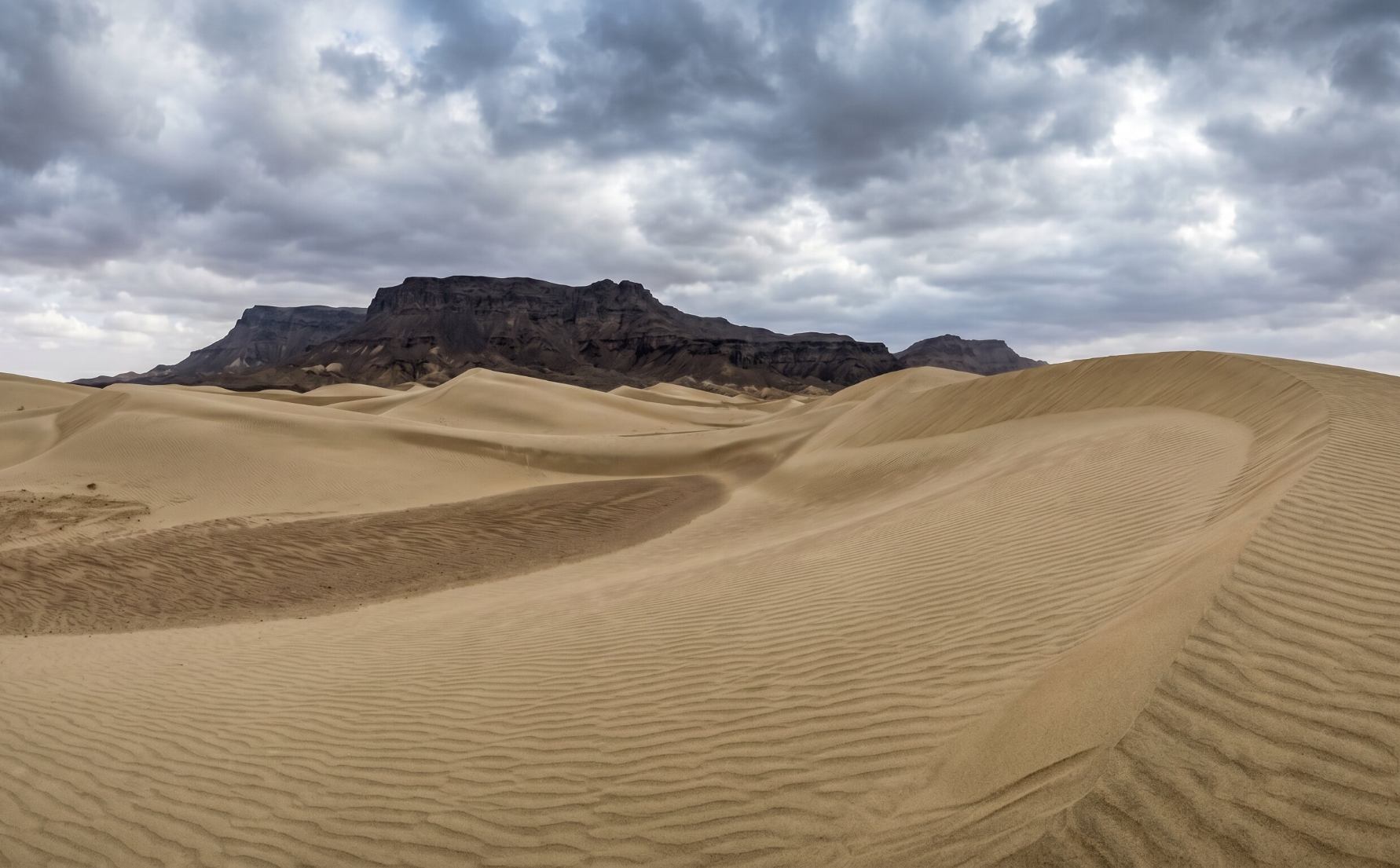
The Kharan Desert, Balochistan, one of the most remote and least-visited landscapes in South Asia, a desert of stark beauty and extraordinary geological character
The Katpana Cold Desert: Where Sand Dunes Meet Snow
The Katpana Desert near Skardu in Gilgit-Baltistan is unlike any other desert in Pakistan and genuinely unlike most deserts anywhere in the world. A cold, high-altitude desert sitting at over 2,200 metres above sea level, Katpana produces one of the most visually surreal landscapes imaginable: golden sand dunes dusted with snow, surrounded by the jagged peaks of the Karakoram. In winter, temperatures drop well below zero while the sand dunes remain, creating a juxtaposition of desert and winter landscape that photographs like something assembled from two different worlds.
Katpana is small compared to the hot deserts of Sindh and Punjab, but it has become one of the most popular photography destinations in the Skardu area. The combination of the dunes, the snow, the surrounding mountain silhouettes, and the extraordinary quality of light at this altitude makes it particularly rewarding in the early morning and at sunset. It is accessible as a day excursion from Skardu and pairs naturally with the wider Skardu basin landscape.
Wildlife Across Pakistan’s Deserts
Far from being lifeless, Pakistan’s deserts support a wide range of specially adapted wildlife that has evolved to survive conditions of extreme heat, minimal water, and sparse vegetation.
The Ancient Civilisations Beneath Pakistan’s Sands
One of the most important and least-told stories about Pakistan’s deserts is their relationship to the ancient Indus Valley Civilisation. The Cholistan Desert, now one of the most arid areas of Punjab, was traversed by the Hakra River, also known historically as the Ghaggar-Hakra or the Saraswati, which supported a dense network of Harappan settlements along its banks. When the river shifted and dried around 2000 BC, the settlements were abandoned, the agricultural land reverted to desert, and an entire chapter of South Asian prehistory was buried under the sand. Pakistani and international archaeologists have identified over 400 ancient sites in Cholistan alone, of which only a fraction have been excavated. The buried city of Ganweriwala in Cholistan is estimated to have been comparable in size to Mohenjo-daro and Harappa, the two most celebrated Indus cities, yet remains largely unexcavated.
The Thar Desert similarly contains ancient temple complexes, including the remarkable Jain temples of Nagarparkar in the Karunjhar Hills at the desert’s southeastern edge, carved from dark granite and dating to the 10th to 14th centuries, standing in the desert as extraordinary and largely unvisited monuments to a pre-Islamic religious tradition that flourished in this landscape a thousand years ago. The Indus Valley Civilisation expedition by Crossroads Adventure explores the full depth of this ancient world through guided visits to Mohenjo-daro and other key sites of the civilisation that once covered much of what is now Pakistan’s desert south.
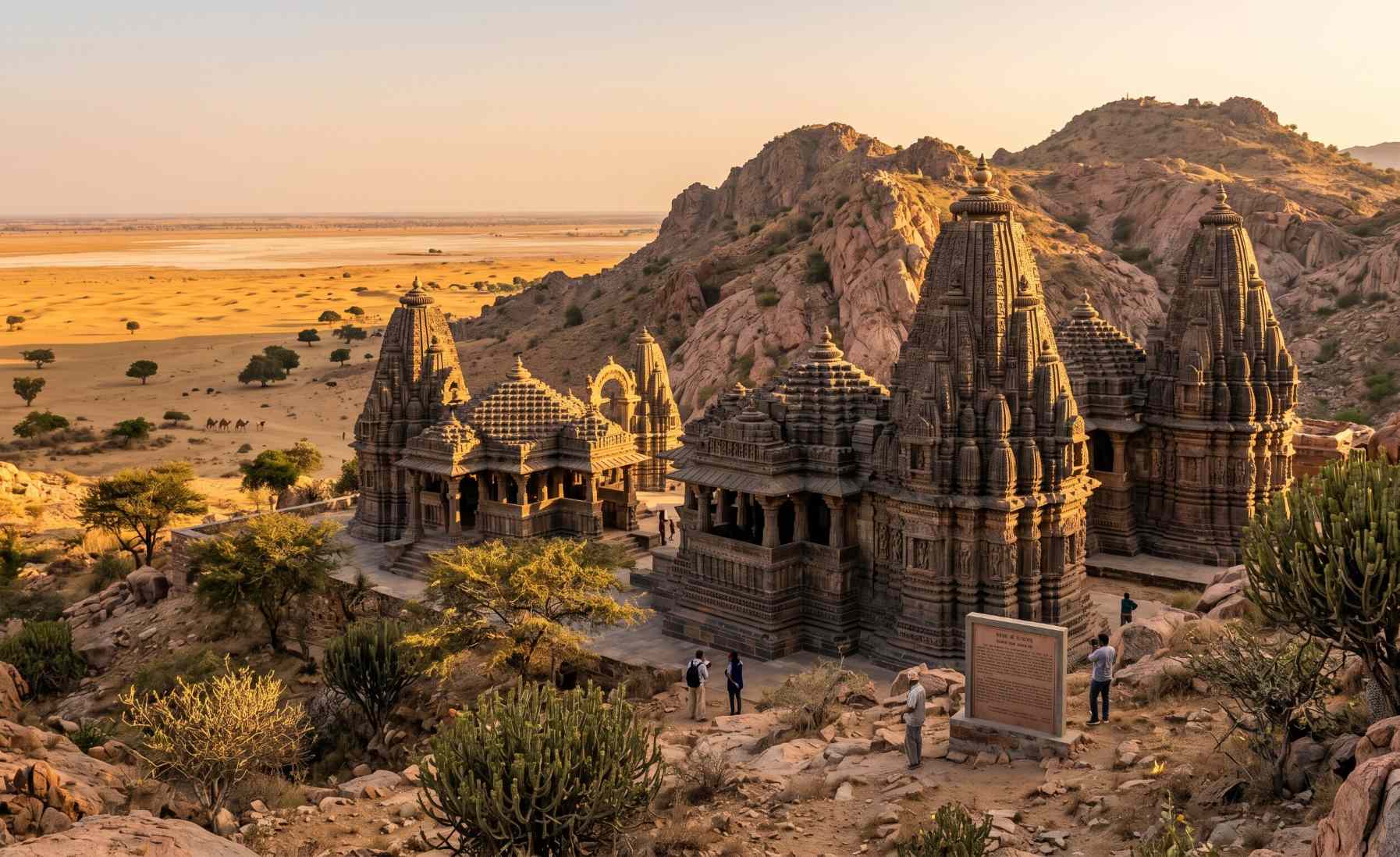
The Jain temples of Nagarparkar, Tharparkar, carved from dark granite between the 10th and 14th centuries, one of the most remarkable and least-visited archaeological sites in Pakistan
Visiting Pakistan’s Deserts: Practical Information
Best Time to Visit
The optimal season for visiting Pakistan’s hot deserts (Thar, Cholistan, Thal, and Kharan) is November through February. Temperatures during these months are mild and comfortable, ranging from 10°C to 25°C during the day. Summer temperatures in the Thar and Cholistan regularly exceed 45°C and can reach 50°C, making travel genuinely dangerous without full preparation. The Cholistan Jeep Rally takes place in February and is an excellent reason to time a Cholistan visit to that month. For the Katpana Cold Desert near Skardu, winter visits from December to February offer the snow-dusted dune experience, while May through September gives clearer skies and access alongside the broader Skardu tourism season.
Getting There
The Thar Desert is most easily accessed from Hyderabad or Mirpurkhas in Sindh, from where the district town of Mithi in Tharparkar is approximately three hours by road. Cholistan is reached from Bahawalpur city in Punjab, which is connected by road and rail from Multan and Lahore. Kharan in Balochistan requires a more extended overland journey from Quetta and benefits significantly from local guide support and advance logistics planning. The Katpana Desert near Skardu is accessible by domestic flight from Islamabad to Skardu, subject to weather conditions, or by road via the Karakoram Highway.
Travel note from the Crossroads team: Pakistan’s desert regions, particularly Balochistan, Tharparkar, and Cholistan, are among the least professionally served by tourism operators in the country. The cultural and historical depth of these landscapes is extraordinary, but independent travel without local contacts, knowledge of road conditions, and community introductions misses most of what makes them worth visiting. Expert guided travel in Pakistan’s desert south transforms these landscapes from difficult-to-access geographical facts into encounters with living culture and ancient history that few international visitors have ever experienced.
Frequently Asked Questions
What is the largest desert in Pakistan?
The Thar Desert in Sindh is the largest desert in Pakistan, covering approximately 175,000 square kilometres including its extension into Indian Rajasthan. Within Pakistan alone it covers the majority of Tharparkar district and extends north into parts of eastern Sindh. It is the world’s 16th largest desert overall and the only major subtropical desert in Asia. Despite its extreme conditions, it supports one of the most densely populated desert regions in the world.
How many deserts are there in Pakistan?
Pakistan has five major deserts: the Thar in Sindh, the Cholistan in Punjab, the Thal in central Punjab, the Kharan in Balochistan, and the Katpana Cold Desert near Skardu in Gilgit-Baltistan. The first four are hot deserts, while Katpana is a high-altitude cold desert and the only one of its kind in Pakistan. Together they cover approximately 11 million hectares of the country’s total land area.
What is the cold desert in Pakistan?
The Katpana Desert near Skardu in Gilgit-Baltistan is Pakistan’s only cold desert. Situated at over 2,200 metres above sea level, it is one of the few high-altitude deserts in the world where sand dunes coexist with sub-zero winter temperatures, creating the extraordinary visual effect of snow-dusted golden dunes against a backdrop of Karakoram peaks. It is accessible as a short excursion from Skardu town and has become one of the most visited photography spots in the region.
Which desert in Pakistan is home to Derawar Fort?
Derawar Fort is located in the Cholistan Desert, approximately 130 kilometres south of Bahawalpur city in southern Punjab. It is one of the finest preserved desert fortresses in South Asia, with 40 intact bastions rising 30 metres above the flat desert floor. The adjacent Abbasi mosque and the royal tombs of the Nawabs of Bahawalpur make the site a complex of considerable historical and architectural significance. Derawar is best visited between November and February to avoid the extreme summer heat of Cholistan.
Is the Thar Desert safe to visit in Pakistan?
Yes. Tharparkar and the broader Thar Desert region in Sindh are safe to visit for travellers, with an established, if modest, tourism infrastructure. The district town of Mithi is the main base for desert exploration. Travelling with a local guide or a professional operator is strongly recommended, both for safety in the more remote areas and for the cultural access that a well-connected guide provides. The best time to visit is November to February. Summer visits are not recommended due to extreme temperatures.
What animals live in Pakistan’s deserts?
Pakistan’s deserts support diverse and specially adapted wildlife. The chinkara gazelle and Indian peacock are the most visible large animals in the Thar. Cholistan is home to desert wolves (rare), caracal cats, red foxes, jackals, blackbuck antelope (critically endangered), and migratory birds including the houbara bustard and saker falcon. Monitor lizards, cobras, saw-scaled vipers, and Russell’s vipers are found across the hot deserts. Dromedary camels, while domesticated, remain the definitive symbol of desert life across all four hot desert regions.
Explore Pakistan’s Desert Heritage with Crossroads Adventure
From the ancient civilisations buried beneath Cholistan’s sand to the living culture of Tharparkar and the extraordinary remoteness of Balochistan, Pakistan’s deserts reward those who explore them with the right expertise and the right guide.
Plan Your Pakistan Desert Journey