Crossroads field guides · Culture & heritage
Silk Road heritage in northern Pakistan is written into river crossings, weathered rock faces, mountain settlements and the timber rooms of old forts. A journey through Gilgit, Hunza and Baltistan becomes more rewarding when these places are read together: as evidence of movement, adaptation and exchange across some of Asia’s most difficult terrain.
This guide explains what the Silk Roads mean in northern Pakistan, which heritage sites deserve time, how to connect them realistically, and where the evidence ends and interpretation begins. It is designed for travellers interested in history, architecture, Buddhism, photography and the living cultures of Gilgit-Baltistan.
Crossroads Adventure · Editorial review: 6 October 2026
What were the Silk Roads in northern Pakistan?
The Silk Roads were a changing network of land and sea connections, rather than one continuous highway with a fixed beginning and end. Goods moved in stages; people travelled for commerce, diplomacy, religious study and other purposes. UNESCO’s overview emphasises the circulation of knowledge and beliefs alongside merchandise. That wider understanding is particularly useful in northern Pakistan, where mountain routes linked neighbouring valleys as well as distant regions. Read UNESCO’s introduction to the Silk Roads.
In the upper Indus region, the practical problem was always terrain. A river valley might offer a direction of travel while a gorge blocked straightforward progress. A pass could connect two communities but remain unavailable during snow. Crossing points, supplies, local knowledge and political relationships mattered as much as distance. For a modern visitor, this means that the landscape itself is part of the historical explanation. The question is not simply where a road went, but how people could move through such a place.
The Karakoram Highway and historical routes
The modern Karakoram Highway provides access to many places associated with earlier movement through the mountains. It should not be described as an unchanged ancient road. Its engineered carriageway, bridges, tunnels and vehicle infrastructure belong to a much later transport system. Earlier travellers used different paths, crossings and passes, sometimes within the same broad geographical corridors.
A roadside sign saying “Silk Route” is therefore an invitation to investigate, rather than proof that every passing caravan used that exact alignment. Ask what survives: an inscription, a documented settlement, a fort, an old path or an oral account. These are different kinds of evidence and deserve different explanations. A careful guide can distinguish them without taking the interest out of the journey.
Trade, faith and everyday survival
A commercial route could also carry monks, manuscripts, artistic ideas and languages. Yet not every mountain household was involved in international commerce. Agriculture, livestock, access to water and local exchange sustained settlements. Keeping these realities together gives a more convincing picture than imagining an uninterrupted procession of silk caravans through every valley.
For visitors, a productive theme is connection. Look at where paths meet, where rivers must be crossed, where a settlement can grow crops, and where a ruler could observe an approach. Then consider what people chose to record or build. A carved religious image and a defensive tower tell different stories, but both become clearer when placed in their landscape.
Silk Road heritage places: what to visit and why
| Place | What it contributes | Practical approach |
|---|---|---|
| Upper Indus rock-art sites around Chilas and Shatial | Carvings and inscriptions associated with many periods and travellers | Specialist-led stops on an appropriate road journey; confirm the particular site and current access |
| Kargah Buddha, Gilgit | A substantial Buddhist image carved into a cliff | A local excursion from Gilgit with interpretation at the viewing area |
| Ganish, Hunza | Historic settlement fabric, communal spaces and conserved wooden mosques | A respectful guided village walk |
| Altit and Baltit forts | Rulership, domestic architecture and conservation | Visit both to compare setting and interpretation |
| Gulmit and Passu, Upper Hunza | Living mountain communities and regional connections | Pre-arranged village experiences with local hosts |
| Manthal Buddha Rock, Skardu | Buddhist heritage in Baltistan | A local visit combined with a quieter Skardu cultural day |
| Shigar Fort and Khaplu Palace | Balti architectural heritage and adaptive reuse | Allow separate time for the buildings and surrounding settlements |
This is a thematic selection, not a claim that all these buildings were caravanserais or that each site formed part of one formally defined route. The Buddhist carvings, Hunza forts and Balti palaces belong to different contexts. Their value lies in helping travellers understand the region’s connections over a long period.
Rock art along the upper Indus: the strongest visible evidence
The Heidelberg Academy of Sciences and Humanities’ research project documents an exceptional concentration of rock art and inscriptions along the upper Indus and associated routes. Its published overview describes more than 50,000 drawings and over 5,000 inscriptions spanning many millennia. These are regional research totals, not the number available at one visitor stop. They include material from different periods; describing the entire collection as Buddhist would be inaccurate. Explore the Heidelberg research project.
At a suitable site, the first impression may be modest: a brown or dark rock surface beside an enormous river landscape. The interest develops through observation. An animal outline, a stupa form, a figure or a short inscription can become visible when the light changes. A knowledgeable interpreter helps distinguish original marks from recent damage and explains why a reading or dating is uncertain.
Chilas and Shatial: plan a specific stop
“See the rock carvings” is too vague for a workable itinerary. Ask your guide to identify the exact site, its route access, the walking surface, the likely viewing conditions and the significance of the material there. Some locations are easier to reach than others. Traffic, road works, local access arrangements and riverbank conditions can change the suitability of a visit.
Do not stop a vehicle abruptly on a narrow highway shoulder. A safe parking place and an appropriate approach should be established first. If a road transfer is already long, one interpreted stop is usually better than several rushed attempts. Travellers who want detailed archaeological study should allocate dedicated time rather than treat the carvings as an incidental photograph between hotel nights.
How to look at ancient rock art
Start by taking in the whole setting, then look at the panel without touching it. Notice whether drawings overlap, whether the rock surface has changed colour, and whether some marks are sharper than others. These observations can lead to questions, but they cannot replace archaeological analysis. A polished surface or dark patina alone does not allow a visitor to assign an exact age.
Do not wet, chalk, scratch, trace or rub carvings to improve visibility. Avoid climbing onto decorated surfaces and keep bags and tripod legs clear of them. Photograph from a stable position. A picture that preserves the surrounding rock and landscape can be more useful than an extreme close-up with no context.
Kargah Buddha: a focused excursion from Gilgit
The Gilgit-Baltistan tourism department identifies Kargah Buddha outside Gilgit and gives a broad fourth-to-seventh-century dating. The image is carved into a cliff, making it a distinct experience from scattered roadside panels. Local traditions concerning the figure should be presented as oral traditions, separately from its archaeological interpretation. Official information on Kargah Buddha.
For planning, use Gilgit as the base and arrange a local vehicle and guide. Confirm current access and combine the visit with an unhurried city or valley experience. Looking up at the figure does not require a high mountain expedition, but the surface between vehicle and viewpoint may still matter to someone with limited mobility. Ask about steps and uneven ground before departure.
Manthal Buddha Rock: a different setting in Baltistan
Manthal Buddha Rock stands on the outskirts of Skardu. The official regional description places this Buddhist heritage within Baltistan’s archaeological landscape. It gives a reason to spend time on Skardu’s cultural history before moving on to lakes or higher country. Official Manthal Buddha Rock information.
Ask for an explanation of the composition rather than only a date. What can be identified confidently? Which details are weathered? How does the site relate to later religious and cultural change in the surrounding region? These questions keep the visit specific. They also avoid the mistaken impression that Buddhist heritage ends at Taxila or Swat.
Hunza’s forts and settlements: reading power and community
Ganish: begin with the settlement
Ganish offers a valuable change of scale after mountains and highways. The interest is in a historic settlement: lanes, communal spaces, building relationships and wooden religious architecture. The Aga Khan Trust for Culture’s awards record identifies the Ganish settlement projects as recipients of a 2002 UNESCO Asia-Pacific heritage conservation award. A conservation award is not the same designation as inscription on the UNESCO World Heritage List. AKTC’s heritage awards record.
Arrange a visit with a local guide and respect boundaries between visitor access and private life. A lane can be historically interesting while still being the route someone uses to carry shopping home. Ask before entering a courtyard or photographing a doorway with residents present. Religious buildings may have access requirements that should be checked locally.
Look beyond decorative details. How do the houses relate to a shared space? Where is water used? How does the settlement sit above or beside the wider valley? A guide who knows the community can explain these relationships much better than a hurried walk focused only on old timber.
Baltit Fort: allow time for its interior and setting
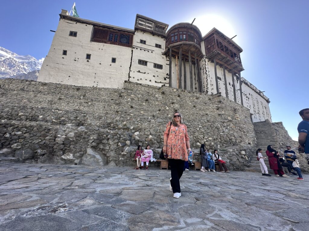
Baltit Fort rises above Karimabad and is interpreted as a historic building rather than simply a mountain viewpoint. The Aga Khan Trust for Culture completed its major conservation intervention in 1996, and its published conservation material describes the fort’s role as a local history museum and cultural centre. AKTC’s Hunza and Baltistan conservation publication.
Plan the approach as part of the visit. The climb through Karimabad is a useful way to understand the settlement, but it is not flat. Travellers with knee problems or limited stamina should discuss the nearest permitted vehicle access, remaining walking distance and interior steps. Allocate time to listen inside before taking photographs outside.
A meaningful visit considers domestic life and administration as well as defence. Ask how different spaces were used, what is original, what was repaired, and how later additions changed the building. This is more informative than reducing the fort to one age or one dramatic story.
Altit Fort: compare, rather than repeat
Altit Fort provides a second perspective on Hunza’s built heritage. Its setting, village approach and interpretation make it worth seeing even after Baltit. The AKDN identifies both among its principal conservation projects in northern Pakistan. AKDN’s northern Pakistan heritage overview.
Visit the buildings on the same day only if the pace remains comfortable. A slower programme can place one fort in the morning and leave space for a village walk, lunch and conversation before the other. If you have only enough energy for one interior visit, choose deliberately and avoid promising both as quick roadside stops.
Upper Hunza: living connections beyond monuments
Gulmit and Passu bring the journey into Upper Hunza, often called Gojal. Their interest should include present-day community life alongside the mountain scenery. The official Passu description identifies living Wakhi traditions and agriculture as part of the village experience. Official Passu village guide.
A locally hosted walk can explore the relationship between homes, fields, irrigation and routes to higher pastures. Such an experience must be arranged with consent; a household is not an open exhibit. Ask your host what they would like visitors to understand about life today. Education, work, technology and changing livelihoods are as relevant as older practices.
Baltistan’s heritage: broaden the journey carefully
Baltistan deserves its own time within a northern Pakistan cultural journey. Adding Skardu, Shigar and Khaplu broadens the story from the Indus and Hunza corridors to Balti settlements and architectural traditions. It does not require pretending that every palace was a Silk Road trading post. Describe this extension as regional heritage and cultural exchange, with the role of each place explained honestly. Our Skardu and Baltistan travel guide explains the valley bases, access and time needed for this extension.
Shigar Fort and the surrounding settlement
The Shigar Fort conservation project combined restoration with a new use as a heritage guesthouse. AKTC’s account explains that conserving the building was linked to cultural and economic objectives rather than the monument alone. Read the Shigar conservation project account.
For a visitor, this raises useful questions. Which areas are open for heritage viewing and which belong to guest accommodation? What can be seen without staying overnight? How does the restored building relate to the village around it? Confirm visitor arrangements before arrival, and allow a local walk where access is welcomed. Booking a hotel room is not a substitute for interpretation.
Khaplu Palace and a slower cultural day
Khaplu Palace is another major restored building within Baltistan. It works best as part of time spent in Khaplu and its surroundings, rather than a distant photograph collected during an already crowded day. Include the road journey, walking, interpretation and a meal in the schedule. Where possible, staying locally gives more space for village experiences.
Religious and civic heritage in Baltistan should be approached with the same care as forts. Some buildings remain in use, and visitor access may vary. A local Balti guide can explain the difference between architectural features, historical traditions and contemporary practice. Ask permission, dress respectfully and give worshippers priority.
How to plan a Silk Road heritage journey in northern Pakistan
The right length depends on the depth you want and how you enter the region. The following structures are planning suggestions, not fixed transport guarantees. Build actual dates around flight availability, road conditions, site access and your walking ability.
A focused Gilgit and Hunza journey
Allow several nights across Gilgit, Central Hunza and Upper Hunza rather than changing accommodation after every attraction. Begin with Kargah Buddha and an introduction to the region. In Central Hunza, give Ganish, Baltit and Altit proper time. Continue to Gojal for a locally hosted experience and discussion of living connections across the mountains. Add roadside archaeology only where it fits the actual route and access. Use the Hunza Valley travel guide to compare Central Hunza and Gojal bases before allocating your nights.
This approach suits travellers who want substantial cultural content without a trek. It also leaves space for mountain viewing. A scenic stop can support the heritage narrative when the guide explains the position of settlements or the difficulty of a crossing, rather than treating history and landscape as separate subjects.
A broader Hunza and Baltistan journey
For the broader version, reserve roughly two weeks as a starting planning envelope, then adjust to transport and desired depth. Spend meaningful nights in Hunza and Baltistan, include Manthal Buddha Rock, and allocate separate attention to Shigar and Khaplu. Avoid putting the longest transfer immediately before an international departure.
Return to Islamabad at least a day before your international flight. That buffer is useful when domestic flights or mountain roads disrupt a carefully arranged programme. A heritage journey should not end with a preventable rush because the itinerary treated every transfer as guaranteed.
For specialist interests
An archaeology-focused visitor may prefer fewer destinations and more time at documented rock-art sites. An architecture enthusiast may place greater emphasis on fort interiors, settlement form and conservation. A photographer might ask for visits timed around suitable light while keeping interpretation and community consent central. Tell your planner which of these interests matters most.
For academic work, filming or research beyond an ordinary visitor experience, establish permissions separately. A normal admission ticket does not necessarily authorise professional recording, access to archives or close examination of protected material. Clarifying this early prevents disappointment at the site.
Access, seasons and practical preparation
Many cultural places lie in inhabited valleys, so this journey does not require the same seasonal window as a high pass expedition. Nevertheless, winter cold, snow on approaches, road disruption and shortened operating hours can affect visits. Spring and autumn can combine heritage with seasonal landscape; summer allows a broader range of mountain additions but may bring busy periods. Confirm the relevant places individually.
There is no single dependable drive time for the whole route. A mountain transfer includes changing road surfaces, traffic, checks, stops and possible delays. Request a route-specific estimate from your operator close to travel, and distinguish driving time from a full day with meals and visits. A map distance alone cannot answer how tiring a transfer will feel.
Carry layers, sun protection, suitable walking shoes and drinking water. Heritage interiors can be dim, narrow or reached by steps. Roadside archaeological ground can be rough. Tell your guide about mobility concerns before the programme is finalised so that worthwhile alternatives can be arranged.
Photography and preservation
Ask about interior photography rules before using a camera. Obtain individual permission for portraits, and parental or guardian permission before photographing children. Do not move objects, climb old walls or use a drone without establishing the applicable permissions. Keep the experience respectful even when the setting is exceptionally photogenic.
Support the places you visit through legitimate admission, local guiding and fairly priced purchases where appropriate. Heritage conservation depends on more than a beautiful restored façade. Visitor behaviour should protect fragile material and respect the people who continue to live around it.
What to ask before booking
- Which exact heritage sites are included, and who will interpret them?
- How much walking, climbing and interior stair use is involved?
- Are admissions and local guides included in the quoted services?
- Which visits depend on permissions or local opening arrangements?
- How are flight disruption and road delays handled?
- How much time is reserved for Islamabad before international departure?
Crossroads Adventure can shape this journey around archaeology, architecture, photography or a balanced introduction to northern Pakistan. The most useful enquiry includes your dates, interests, preferred pace and any mobility requirements. From there, the route can be made specific rather than relying on a generic list of famous places.
Frequently asked questions
Is the Karakoram Highway the original Silk Road?
It is a modern highway through a region with earlier route networks. Some broad corridors overlap, but the engineered road should not be presented as an unchanged ancient alignment.
Where can I see Silk Road heritage in northern Pakistan?
Useful starting points include upper Indus rock-art sites, Kargah Buddha, Hunza’s historic settlements and forts, and Buddhist and architectural heritage in Baltistan. Their historical roles differ, so interpretation matters.
Are Hunza’s forts UNESCO World Heritage Sites?
Do not confuse UNESCO Asia-Pacific conservation awards with World Heritage inscription. When a conservation award is mentioned, name that award accurately rather than using “UNESCO-listed” as shorthand.
Can this journey be done without trekking?
Yes. A cultural programme can use road access and local walks. Some forts involve steep approaches or stairs, and rock-art sites may have uneven ground. Adapt the visits to your ability.
Should I include Baltistan?
Include it if you have time for a broader cultural journey. Skardu, Shigar and Khaplu add Buddhist and Balti architectural heritage, but they deserve dedicated nights and should not be squeezed into a rushed extension.
Do I need a specialist guide?
A knowledgeable local guide is especially valuable for archaeology, conservation and living settlements. For a focused research interest, discuss the required expertise in advance rather than assume every guide has the same specialism.
Sources and further reading
This guide draws on UNESCO’s Silk Roads overview, the Heidelberg Academy’s rock-art research, official Gilgit-Baltistan destination information and published AKTC conservation accounts linked above. Historical interpretation is separated from practical itinerary suggestions. Admission arrangements, road access and opening hours should be confirmed for the intended travel dates.
Continue exploring northern Pakistan
Plan your northern Pakistan journey
Share your dates, interests, walking ability and preferred pace. Crossroads Adventure can shape a private journey around the places and experiences that matter to you.
Start planning your journey